Carquinez_Strait_aerial_view.jpg

Size of this preview:
800 × 533 pixels
.
Other resolutions:
320 × 213 pixels
|
640 × 426 pixels
|
1,024 × 682 pixels
|
1,500 × 999 pixels
.
| Description |
English:
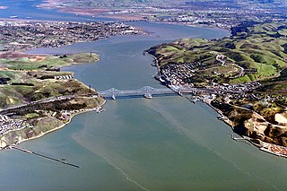
Aerial view of Carquinez Strait, which is the outflow of the Sacramento River into San Pablo Bay between Solano and Contra Costa Counties, California, USA. In the photograph, Solano County is on the left of the strait and Contra Costa County is on the right. The Carquinez Bridge, carrying Interstate 80, is visible in the foreground. The Benicia-Martinez Bridge is visible in the far distance. The communities of Crocket, Port Costa, and Martinez lie on the right side in Contra Costa County. The city of Vallejo lies off to the left, not visible in the picture. Benicia, California, is visible at top left. Through Carquinez Strait and Suisun Bay, the river is navigable by deep-water vessels.
Coordinates:
38°3′43.25″N
122°13′34.18″W
/
38.0620139°N 122.2261611°W
|
||
| Date | not specified or unknown | ||
| Source |
U.S. Army Corps of Engineers Digital Visual Library
Image page Image description page Digital Visual Library home page |
||
| Author | Robert Campbell | ||
|
Permission
( Reusing this file ) |
This file is licensed under the
Creative Commons
Attribution-Share Alike 3.0 Unported
license.
|
||
| Location | Solano and Contra Costa Counties, California, USA |
