Castle_Pines_Village,_Colorado.JPG

Size of this preview:
800 × 589 pixels
.
Other resolutions:
320 × 235 pixels
|
640 × 471 pixels
|
1,024 × 753 pixels
|
1,280 × 942 pixels
|
2,560 × 1,883 pixels
|
4,835 × 3,557 pixels
.
Summary
| Description |
English:
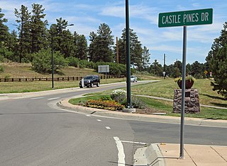
A view of
Castle Pines Village, Colorado
. The view shows the lower traffic circle near the shopping center on East Happy Canyon Road, where it connects with Castle Pines Drive.
|
| Date | |
| Source | Own work |
| Author | Jeffrey Beall |
| Camera location |
|
View this and other nearby images on: OpenStreetMap |
|
|---|
Licensing
I, the copyright holder of this work, hereby publish it under the following license:
This file is licensed under the
Creative Commons
Attribution 4.0 International
license.
-
You are free:
- to share – to copy, distribute and transmit the work
- to remix – to adapt the work
-
Under the following conditions:
- attribution – You must give appropriate credit, provide a link to the license, and indicate if changes were made. You may do so in any reasonable manner, but not in any way that suggests the licensor endorses you or your use.