Cedar_Grove_Planatation_02.jpg

Size of this preview:
800 × 600 pixels
.
Other resolutions:
320 × 240 pixels
|
640 × 480 pixels
|
1,024 × 768 pixels
|
1,280 × 960 pixels
|
2,560 × 1,920 pixels
|
3,072 × 2,304 pixels
.
|
|
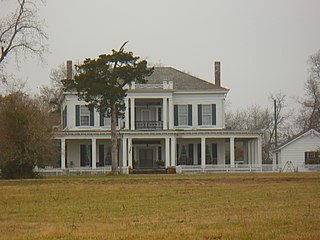
This is an image of a place or building that is listed on the
National Register of Historic Places
in the
United States of America
. Its reference number is
93000599
.
|
Summary
| Description |
English:
Cedar Grove Plantation near Faunsdale, Marengo County, Alabama.
|
||
| Date | |||
| Source | Own work | ||
| Author | Altairisfar | ||
|
Permission
( Reusing this file ) |
|
| Object location |
|
View this and other nearby images on: OpenStreetMap |
|
|---|