China_County-level.png

Size of this preview:
759 × 600 pixels
.
Other resolutions:
304 × 240 pixels
|
607 × 480 pixels
|
972 × 768 pixels
|
1,280 × 1,012 pixels
|
2,560 × 2,023 pixels
|
6,246 × 4,937 pixels
.


|
This image is expected to always be the most recent one. Feel free to update it when needed.
|

|
This file may be updated to reflect new information.
If you wish to use a specific version of the file without new updates being mirrored, please upload the required version as a separate file. |
Summary
| Description |
English:
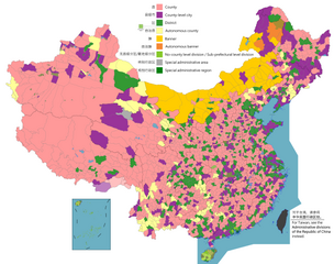
Map of China, shows counties, county-level cities, county-level districts, autonomous counties and banners, banners, etc.
日本語:
中国の地図は、郡、郡レベルの都市、郡レベルの地区、自治県とバナー、バナーなどを示しています。
Русский:
Карта Китая, показывает уезды, города уездного уровня, уездные районы, автономные уезды и баннеры, баннеры и т. Д.
中文(简体):
中国地图,显示县、县级市、县级区、自治县和旗、自治旗等。
中文(繁體):
中國地圖,顯示縣、縣級市、縣級區、自治縣和旗、自治旗等。
|
||
| Date |
|
||
| Source |
Legend :
English:
County
County-level city
County-level district
Autonomous county
Banner
Autonomous banner
No county-level division / Sub-prefectural level division
Special district
Special administrative region
中文(简体):
县
县级市
县级区
自治县
旗
自治旗
无县级/副地级
特区
特别行政区
|
||
| Author |
|
||
|
Permission
( Reusing this file ) |
Map of China, administrative divisions:
I, the copyright holder of this work, hereby publish it under the following license:
|
Licensing
I, the copyright holder of this work, hereby publish it under the following license:
This file is licensed under the
Creative Commons
Attribution-Share Alike 4.0 International
license.
-
You are free:
- to share – to copy, distribute and transmit the work
- to remix – to adapt the work
-
Under the following conditions:
- attribution – You must give appropriate credit, provide a link to the license, and indicate if changes were made. You may do so in any reasonable manner, but not in any way that suggests the licensor endorses you or your use.
- share alike – If you remix, transform, or build upon the material, you must distribute your contributions under the same or compatible license as the original.

|
This
map
image could be re-created
using
vector graphics
as an
SVG
file
. This has several advantages; see
Commons:Media for cleanup
for more information. If an SVG form of this image is available, please upload it and afterwards replace this template with
{{

vector version available

|

new image name

}}
.
It is recommended to name the SVG file “China county-level divisions and administrative divisions (PRoC claim).svg”—then the template Vector version available (or Vva ) does not need the new image name parameter. |
| Annotations | This image is annotated: View the annotations at Commons |
.png)