Ckk-83-1_c22_4-5_kamishima.jpg

Size of this preview:
552 × 600 pixels
.
Other resolutions:
221 × 240 pixels
|
442 × 480 pixels
|
707 × 768 pixels
|
942 × 1,024 pixels
|
2,300 × 2,500 pixels
.
| Description |
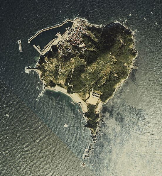
English:
Aerial Photo of Kami-shima, Toba City, Mie, Japan, 1983.
|
| Date |
日本語:
昭和58年度
|
| Source |
国土画像情報(カラー空中写真)(整理番号:CKK-83-1、撮影年度:昭和58年度、地区名:伊勢、撮影縮尺:1/10000、地形図番号:NI-53-9-1、5万分の1地形図名:答志、撮影コース:C22)
http://w3land.mlit.go.jp/Air/photo400/83/ckk-83-1/c22/ckk-83-1_c22_4.jpg
http://w3land.mlit.go.jp/Air/photo400/83/ckk-83-1/c22/ckk-83-1_c22_5.jpg
|
| Author |
日本語:
国土地理院
|

|
The copyright holder of this file, the Ministry of Land, Infrastructure, Transport and Tourism of Japan , allows anyone to use it for any purpose, provided that the copyright holder is properly attributed. Redistribution, derivative work, commercial use, and all other use is permitted. |
|
Attribution:
Copyright ©
National Land Image Information (Color Aerial Photographs)
, Ministry of Land, Infrastructure, Transport and Tourism
|

|
This image is copyrighted by
the Ministry of Land, Infrastructure, Transport and Tourism of Japan
. For terms of use, see
the stipulation to use of National Land Information
(in Japanese) and
message from MLIT
(in Japanese and English). When you display this image on an article, include the following phrase in the description: "
Made based on
National Land Image Information (Color Aerial Photographs)
, Ministry of Land, Infrastructure, Transport and Tourism
".
|