Cliffe_Roman_Bridge_2.jpg
No higher resolution available.
Summary
| Description |
English:
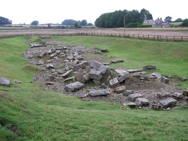
Source description says: "Roman Bridge : Piercebridge
On the south bank of the River Tees, an excavated site with the remains of abutments and piers. On the course of Dere Street Roman road." View across Tees from Cliffe, Richmondshire. This bridge was once part of the Roman road Dere Street, which is now diverted.
|
| Date | |
| Source | https://www.geograph.org.uk/photo/221838 |
| Author | Hugh Mortimer |
|
Permission
( Reusing this file ) |
© Copyright Hugh Mortimer and licensed for reuse under this Creative Commons Licence.Under the Creative Commons Licence, the image must be credited as specified by the contributor, an example of good wording is shown above. (The contributor of this photos is Hugh Mortimer).You should also mention that the photo is copyrighted but also licensed for further reuse. If you alter, transform, or build upon this work, you may distribute the resulting work only under a similar licence. |
| Camera location |
|
View this and other nearby images on: OpenStreetMap |
|
|---|
_heading:202.00&language=en)
| Object location |
|
View this and other nearby images on: OpenStreetMap |
|
|---|
_heading:202.00&language=en)
OSGB36: NZ 215 154 [100m precision] WGS84: 54:32.0054N 1:40.1558W
Licensing

|
This image was taken from the
Geograph project
collection. See
this photograph's page
on the Geograph website for the photographer's contact details. The copyright on this image is owned by
Hugh Mortimer
and is licensed for reuse under the
Creative Commons
Attribution-ShareAlike 2.0 license.
|
This file is licensed under the
Creative Commons
Attribution-Share Alike 2.0 Generic
license.
Attribution:
Hugh Mortimer
-
You are free:
- to share – to copy, distribute and transmit the work
- to remix – to adapt the work
-
Under the following conditions:
- attribution – You must give appropriate credit, provide a link to the license, and indicate if changes were made. You may do so in any reasonable manner, but not in any way that suggests the licensor endorses you or your use.
- share alike – If you remix, transform, or build upon the material, you must distribute your contributions under the same or compatible license as the original.