Clyde_sandbanks,_Tail_of_the_Bank_and_Ardmore_Point.jpg

Size of this preview:
800 × 450 pixels
.
Other resolutions:
320 × 180 pixels
|
640 × 360 pixels
|
1,024 × 576 pixels
|
1,280 × 720 pixels
|
2,560 × 1,440 pixels
|
3,898 × 2,193 pixels
.
Summary
| Description |
English:
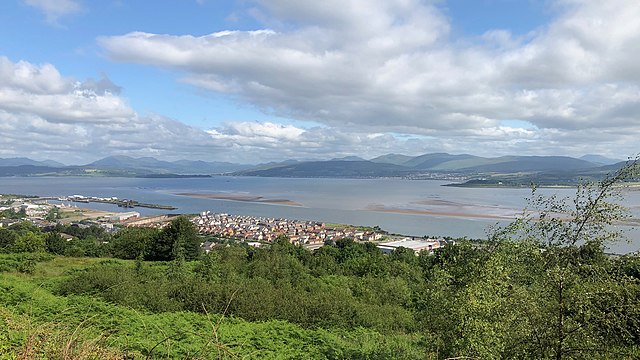
View northwest over the
River Clyde
estuary to the
Tail of the Bank
where it deepens into the
Firth of Clyde
. The dredged navigable channel goes along the south shore past developments on the former
Lithgows
shipyard in Port Glasgow, and
Greenock
's Great Harbour. The Greenock Bank forms a
sandbank and shoal
extending across the estuary to the Ardmore Point peninsula on the north shore, near
Cardross
. The Gare Loch is directly ahead, with the town of
Helensburgh
to its right, the
Rosneath Peninsula
to its left. The wreck of
MV
Captayannis
is in line with the Gare Loch.
|
| Date | |
| Source | Own work |
| Author | dave souza |
| Camera location |
|
View this and other nearby images on: OpenStreetMap |
|
|---|
Licensing
I, the copyright holder of this work, hereby publish it under the following license:
This file is licensed under the
Creative Commons
Attribution-Share Alike 4.0 International
license.
-
You are free:
- to share – to copy, distribute and transmit the work
- to remix – to adapt the work
-
Under the following conditions:
- attribution – You must give appropriate credit, provide a link to the license, and indicate if changes were made. You may do so in any reasonable manner, but not in any way that suggests the licensor endorses you or your use.
- share alike – If you remix, transform, or build upon the material, you must distribute your contributions under the same or compatible license as the original.