Cold_war_europe_military_alliances_map_en.png

Size of this preview:
582 × 599 pixels
.
Other resolutions:
233 × 240 pixels
|
466 × 480 pixels
|
746 × 768 pixels
|
1,165 × 1,200 pixels
.

|
This
military map
image could be re-created
using
vector graphics
as an
SVG
file
. This has several advantages; see
Commons:Media for cleanup
for more information. If an SVG form of this image is available, please upload it and afterwards replace this template with
{{

vector version available

|

new image name

}}
.
It is recommended to name the SVG file “Cold war europe military alliances map en.svg”—then the template Vector version available (or Vva ) does not need the new image name parameter. |
Summary
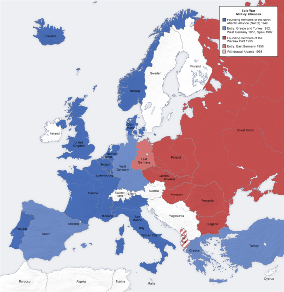
- Description: military alliances in the Cold war, map de
- Source: own map, based on the Generic Mapping Tools archive copy at the Wayback Machine and ETOPO2 archive copy at the Wayback Machine
- Author: San Jose , 7 October 2006
- Other versions: German , French , Classical Chinese , without text , Arabic
Licensing
|
|
The map has been created with the
Generic Mapping Tools
:
https://www.generic-mapping-tools.org/
using one or more of these
public-domain
datasets for the relief:
|

|
Permission is granted to copy, distribute and/or modify this document under the terms of the GNU Free Documentation License , Version 1.2 or any later version published by the Free Software Foundation ; with no Invariant Sections, no Front-Cover Texts, and no Back-Cover Texts. A copy of the license is included in the section entitled GNU Free Documentation License . |
|
|
This file is licensed under the Creative Commons Attribution-Share Alike 3.0 Unported license. | |
|
||
| This licensing tag was added to this file as part of the GFDL licensing update . |
_en.png)
.png)
.jpg)