Continental_West_Germanic_languages.png

Size of this preview:
462 × 600 pixels
.
Other resolutions:
185 × 240 pixels
|
370 × 480 pixels
|
591 × 768 pixels
|
789 × 1,024 pixels
|
1,796 × 2,332 pixels
.

|
This file requires updating because:
"complety" to "completely"
In doing so, you could add a timestamp to the file.
|


|
This
linguistic map
image could be re-created
using
vector graphics
as an
SVG
file
. This has several advantages; see
Commons:Media for cleanup
for more information. If an SVG form of this image is available, please upload it and afterwards replace this template with
{{

vector version available

|

new image name

}}
.
It is recommended to name the SVG file “Continental West Germanic languages.svg”—then the template Vector version available (or Vva ) does not need the new image name parameter. |
| Description |
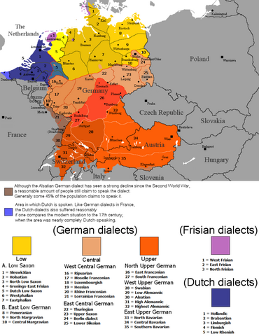
English:
The dialectal ranges (not those of standard languages!) of the Continental West Germanic languages (Dutch/Frisian/German) after 1945
|
||
| Source |
|
||
| Author | Rex Germanus | ||
|
Permission
( Reusing this file ) |
|
