Contour_map_with_an_example_fall_line.jpg
No higher resolution available.
Summary
| Description |
English:
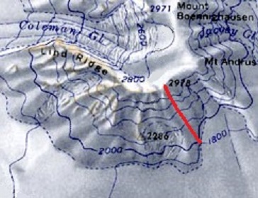
Contour map with an example fall line. Contour lines of constant elevation are blue, and one example fall line is red.
|
| Date | |
| Source | Own work |
| Author | LithiumFlash (This image was created by modifying File:AmesRangeMap.jpg . The original image is in the public domain in the United States because it only contains materials that originally came from the United States Geological Survey, an agency of the United States Department of the Interior. For more information, see the official USGS copyright policy). |
Licensing
I, the copyright holder of this work, hereby publish it under the following license:
This file is licensed under the
Creative Commons
Attribution-Share Alike 4.0 International
license.
-
You are free:
- to share – to copy, distribute and transmit the work
- to remix – to adapt the work
-
Under the following conditions:
- attribution – You must give appropriate credit, provide a link to the license, and indicate if changes were made. You may do so in any reasonable manner, but not in any way that suggests the licensor endorses you or your use.
- share alike – If you remix, transform, or build upon the material, you must distribute your contributions under the same or compatible license as the original.