Cook_Islands_(New_Zealand)_map.png
No higher resolution available.
Summary
| Description |
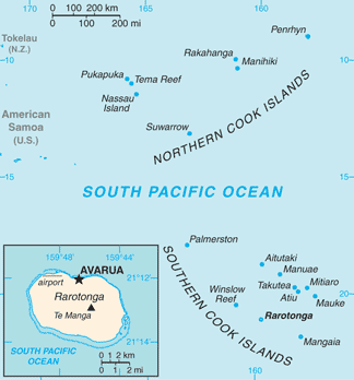
English:
Map of Cook Islands (New Zealand)
Italiano:
Mappa delle Isole Cook (Nuova Zelanda)
|
|||
| Date | ||||
| Source | https://www.cia.gov/library/publications/the-world-factbook/geos/cw.html | |||
| Author | Directorate of Intelligence, CIA | |||
|
Permission
( Reusing this file ) |
|
Licensing
|
|
This image is in the
public domain
because it contains materials that originally came from the United States
Central Intelligence Agency
's
World Factbook
.
|

|
Original upload log
| Date/Time | Dimensions | User | Comment |
|---|---|---|---|
| 16 March 2013, 18:45:06 | 328 × 353 (19796 bytes) | Edoardo Cavaleri ( talk · contribs ) | {{Information |Description ={{en|1=Map of Cook Islands (New Zealand)}} {{it|1=Mappa delle Isole Cook (Nuova Zelanda)}} |Source =https://www.cia.gov/library/publications/the-world-factbook/geos/cw.html |Author =Directorate of Intellig... |