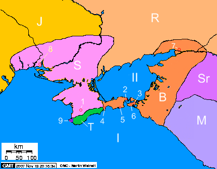
Crimea_2nd_century_BC_map.png
No higher resolution available.
Description of the map-Opis mapy
:
-
Seas - morza
-
I) Black Sea – Morze Czarne
-
II) Sea of Azov - Morze Azowskie
-
I) Black Sea – Morze Czarne
-
Cities - miasta
-
1) Scythians Neapolis - Neapol Scytyjski
-
2) Panticapaeum - Pantikapajon
-
3) Phanagoria - Fanagoria
-
4) Feodosiya - Teodozja
-
5) Kimmerikon
-
6) Hermonassa
-
7) Tanais
-
8) Olbia
-
9) Chersonesos - Chersonez Taurydzki
-
1) Scythians Neapolis - Neapol Scytyjski
-
Peoples and states – Ludy i państwa
-
S) State of Scythians on Crimea – Państwo scytyjskie na Krymia
-
B) Bosporan Kingdom – Królestwo Bosporańskie
-
J) Iazyges - Jazygowie
-
R) Rhoxolani - Roksolanie
-
Sr) Siraces - Syrakowie
-
M) Maeotae – Meotowie
- T) Tauri - Taurowie
-
S) State of Scythians on Crimea – Państwo scytyjskie na Krymia
| Description |
English:
The map of Crimea, 2 century BC
Polski:
Krym w II wieku p.n.e.
|
||
| Date | 15.09 - 19.11.2007 | ||
| Source | Own work , on the basis of publications: "Atlas Historii Świata"( Atlas of the World's History, Warszawa - Wrocław, edit. PPWK, 1986), Smirnov A. "Scytowie" (Scythians, edit. PIW, Warszawa, 1974), and maps from WWW: [1] , [2] | ||
| Author | Janmad | ||
|
Permission
( Reusing this file ) |
I, the copyright holder of this work, hereby publish it under the following licenses:
This file is licensed under the
Creative Commons
Attribution 3.0 Unported
license.
You may select the license of your choice.
|

![[1]](http://aors.narod.ru/images/Sarmat.gif)