Cromford_1775_mill.jpg

Size of this preview:
800 × 302 pixels
.
Other resolutions:
320 × 121 pixels
|
1,000 × 377 pixels
.
Summary
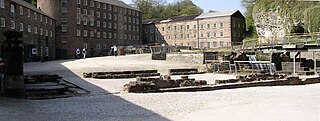
| Description | The foundations of the 1775 mill which was destroyed by fire in 1890, with wheel chamber on the right. |
| Date | |
| Source | Own work |
| Author | chevin |
|
Permission
( Reusing this file ) |
free use |
| Camera location |
|
View this and other nearby images on: OpenStreetMap |
|
|---|
Licensing
|
|
I, the copyright holder of this work, release this work into the
public domain
. This applies worldwide.
In some countries this may not be legally possible; if so: I grant anyone the right to use this work for any purpose , without any conditions, unless such conditions are required by law. |