Dam_on_Northwest_Branch_of_Anacostia_River,_taken_from_the_ridge_looking_north._-_Robert_B._Morse_Water_Filtration_Plant,_10700_and_10701_Columbia_Pike,_Silver_Spring,_Montgomery_County_HAER_MD-166-20.tif

Size of this JPG preview of this TIF file:
800 × 571 pixels
.
Other resolutions:
320 × 229 pixels
|
640 × 457 pixels
|
1,024 × 731 pixels
|
1,280 × 914 pixels
|
2,560 × 1,829 pixels
|
4,943 × 3,531 pixels
.
Summary
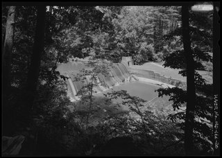
| Dam on Northwest Branch of Anacostia River, taken from the ridge looking north. - Robert B. Morse Water Filtration Plant, 10700 and 10701 Columbia Pike, Silver Spring, Montgomery County, MD | ||||
|---|---|---|---|---|
| Photographer |
Bieretz, Renee
|
|||
| Title |
Dam on Northwest Branch of Anacostia River, taken from the ridge looking north. - Robert B. Morse Water Filtration Plant, 10700 and 10701 Columbia Pike, Silver Spring, Montgomery County, MD
|
|||
| Description |
Morse, Robert B; Washington Suburban Sanitary Commission; Maryland-National Capital Park and Planning Commission; Wherley, Charles O; Chicago Bridge and Iron Works Company; Prince George's and Montgomery Counties Sewerage Commission; Bureau of Sanitary Engineering; Maryland State Department of Health; Reconstruction Finance Corporation; Gibb, John; Aldrich, Elwood H; Kirkwood, James P; Maryland-National Capital Park and Planning Commission, sponsor; Mueller, Julie, sponsor; Lampl, Elizabeth Jo, sponsor; Watts, Alden, researcher; Marston, Christopher, project manager
|
|||
| Depicted place | Maryland; Montgomery County; Silver Spring | |||
| Date | Documentation compiled after 1968; 2008 | |||
| Dimensions | 5 x 7 in. | |||
| Current location |
Library of Congress Prints and Photographs Division Washington, D.C. 20540 USA
http://hdl.loc.gov/loc.pnp/pp.print
|
|||
| Accession number |
HAER MD-166-20
|
|||
| Credit line |
|
|||
| Notes |
|
|||
| Source | https://www.loc.gov/pictures/item/md1796.photos.574342p | |||
|
Permission
( Reusing this file ) |
|
|||

| Object location |
|
View this and other nearby images on: OpenStreetMap |
|
|---|