DeSoto_Map_HRoe_2008.jpg
Size of this preview:
759 × 600 pixels
.
Other resolutions:
304 × 240 pixels
|
608 × 480 pixels
|
810 × 640 pixels
.
Summary
| Description |
English:
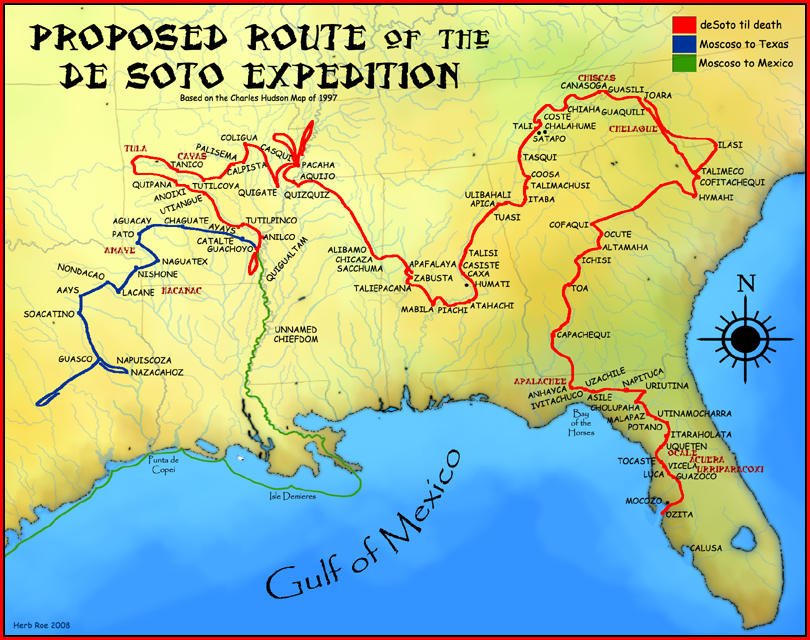
A map showing the proposed route of the
de Soto Expedition
, based on the 1997
Charles Hudson
map.
|
| Date |
19 September 2008 (original upload date)
|
| Source | Created by Herb Roe 2008. |
| Author | Heironymous Rowe ( talk ) |
Licensing
This file is licensed under the
Creative Commons
Attribution-Share Alike 3.0 Unported
license.
Attribution:
Herb Roe
-
You are free:
- to share – to copy, distribute and transmit the work
- to remix – to adapt the work
-
Under the following conditions:
- attribution – You must give appropriate credit, provide a link to the license, and indicate if changes were made. You may do so in any reasonable manner, but not in any way that suggests the licensor endorses you or your use.
- share alike – If you remix, transform, or build upon the material, you must distribute your contributions under the same or compatible license as the original.
Original upload log
Transferred from en.wikipedia to Commons by Spyder_Monkey using CommonsHelper .
The original description page was
here
. All following user names refer to en.wikipedia.
- 2008-09-19 22:27 Heironymous Rowe 810×640× (542344 bytes) {{Information |Description=A map showing the proposed route of the de Soto Expedition, based on the 1997 [[Charles M. Hudson(author)|Charles Hudson]] map. |Source=I created this work entirely by myself. |Date=2008 |Author=~~~ |other_versions= }}