Districts_of_Copenhagen_municipality_2007.svg

Size of this PNG preview of this SVG file:
600 × 600 pixels
.
Other resolutions:
240 × 240 pixels
|
480 × 480 pixels
|
768 × 768 pixels
|
1,024 × 1,024 pixels
|
2,048 × 2,048 pixels
|
870 × 870 pixels
.
| Description |
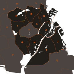
English:
Districts of
Copenhagen municipality
(January 1, 2007 —>)
— the borders of the districts were based primarily on these sources
Distriktsinddelinger i København
(
archived
),
Københavns bydele med rodeinddeling
(
archived
),
Københavns bydele
(
archived
),
Fokus på social ulighed (Region Hovedstaden)
(
archived
) and detailed maps of Copenhagen and surrounding municipalities. The 10 administrative districts (
bydele
/
distrikter
) are:
The surrounding municipalities are: |
| Date | |
| Source | Own work |
| Author | Froztbyte |
|
Permission
( Reusing this file ) |
Attribution required
:
This illustration
was created by
Froztbyte
(
e-mail me
)
If you use this illustration outside the Wikimedia projects please credit this way: © www.mysona.dk
I, the copyright holder of this work, hereby publish it under the following license:
This file is licensed under the
Creative Commons
Attribution-Share Alike 3.0 Unported
license.
|