Donetsk–Krivoy_Rog_Soviet_Republic_map.png
No higher resolution available.
Summary
| Description |
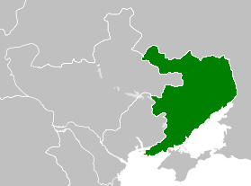
English:
The Donbass-Krivoi Rog Autonomous Republic, its borders were along the western edge of Kharkov and Ekaterinoslav provinces and along the railway to Krivoi Rog, also included the coal areas of the Don Cossack territory, the coast of the Sea of Azov to Taganrog, and a section of the Rostov-Voronezh railway north to Likhaia station.
[1]
Русский:
Донбасско-Криворожская автономная республика, границы которой проходили по западной окраине Харьковской и Екатеринославской губерний и вдоль железной дороги на Кривой Рог, включала также угольные районы Донского казачьего края, побережье Азовского моря до Таганрога и участок железной дороги Ростов-Воронеж на север до станции Лихая.
中文:
顿巴斯-克里沃罗格自治共和国,其边界位于哈尔科夫省和叶卡捷琳诺斯拉夫省的西部边缘以及通往克里沃罗格的铁路沿线,还包括顿河哥萨克地区的煤炭区、亚速海沿岸到塔甘罗格,以及 罗斯托夫-沃罗涅日铁路以北到利哈亚站的一段路段。
|
| Date | |
| Source | Own work |
| Author | Underscore1234 |
Licensing
I, the copyright holder of this work, hereby publish it under the following license:
|
|
This file is made available under the Creative Commons CC0 1.0 Universal Public Domain Dedication . |
|
The person who associated a work with this deed has dedicated the work to the
public domain
by waiving all of their rights to the work worldwide under copyright law, including all related and neighboring rights, to the extent allowed by law. You can copy, modify, distribute and perform the work, even for commercial purposes, all without asking permission.
|
Ref
- ↑ (1994) Iuzovka and Revolution : Politics and Revolution in Russia's Donbass, 1869-1924 , II, New Jersey : Princeton University Press, pp. 351−352 ISBN : 0-691-08660-5 .