Educational_separation_in_the_US_prior_to_Brown_Map.svg

Size of this PNG preview of this SVG file:
512 × 361 pixels
.
Other resolutions:
320 × 226 pixels
|
640 × 451 pixels
|
1,024 × 722 pixels
|
1,280 × 903 pixels
|
2,560 × 1,805 pixels
.
Summary
| Description |
English:
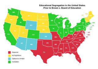
Map of the United States, showing school segregation laws before the Supreme Court case of
Brown v. Board of Education
.
|
| Date | original upload 05:16, 8 April 2007 |
| Source | Created by King of Hearts using information from Image:Educational seperation in the US prior to Brown Map.PNG (PD) and File:Blank US Electoral Map.svg (GFDL) as a template. |
| Author | User:King_of_Hearts |
| Other versions |
This
vector image
includes elements that have been taken or adapted from this file:
This
vector image
includes elements that have been taken or adapted from this file:
.svg)

This
W3C-unspecified
vector image
was created with
Inkscape
.
|
Licensing
I, the copyright holder of this work, hereby publish it under the following license:

|
Permission is granted to copy, distribute and/or modify this document under the terms of the GNU Free Documentation License , Version 1.2 or any later version published by the Free Software Foundation ; with no Invariant Sections, no Front-Cover Texts, and no Back-Cover Texts. A copy of the license is included in the section entitled GNU Free Documentation License . |
|
|
This file is licensed under the Creative Commons Attribution-Share Alike 3.0 Unported license. | |
|
||
| This licensing tag was added to this file as part of the GFDL licensing update . |