European_Spaces.png

Size of this preview:
800 × 566 pixels
.
Other resolutions:
320 × 226 pixels
|
640 × 453 pixels
|
1,024 × 724 pixels
|
1,280 × 906 pixels
|
2,560 × 1,811 pixels
|
3,507 × 2,481 pixels
.

|
File:European Spaces Map.svg
is a vector version of this file. It should be used in place of this PNG file when not inferior.
File:European Spaces.png →
File:European Spaces Map.svg
For more information, see
Help:SVG
.
|

|
Summary
| Description |
English:
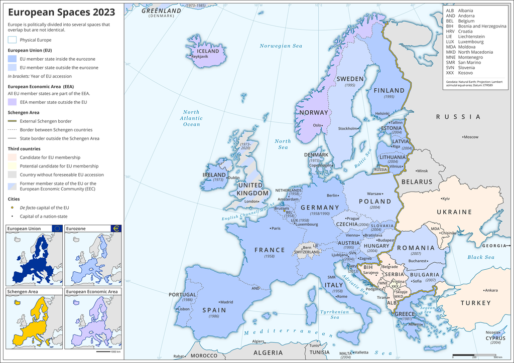
The map shows different (political as well as economic) spaces in Europe, such as the
European Union
(EU), the
Eurozone
, the
European Economic Area
(EEA), the
Schengen Area
, but also (potential)
EU accession candidates
and former EU member states.
Deutsch:
Die Karte zeigt verschiedene (politische und ökonomische) Räume in Europa, so die
Europäische Union
(EU), die
Eurozone
, den
Europäischen Wirtschaftsraum
(EWR), den
Schengen-Raum
, aber auch (potentielle)
EU-Beitrittskandidaten
und frühere EU-Mitglieder.
|
| Date | |
| Source | Own work |
| Author | Domser |
Licensing
I, the copyright holder of this work, hereby publish it under the following license:
This file is licensed under the
Creative Commons
Attribution-Share Alike 4.0 International
license.
-
You are free:
- to share – to copy, distribute and transmit the work
- to remix – to adapt the work
-
Under the following conditions:
- attribution – You must give appropriate credit, provide a link to the license, and indicate if changes were made. You may do so in any reasonable manner, but not in any way that suggests the licensor endorses you or your use.
- share alike – If you remix, transform, or build upon the material, you must distribute your contributions under the same or compatible license as the original.