Fertiliser,_Farming_and_Ferry_-_geograph.org.uk_-_1737437.jpg

Size of this preview:
800 × 591 pixels
.
Other resolutions:
320 × 236 pixels
|
640 × 473 pixels
|
1,024 × 756 pixels
|
1,280 × 945 pixels
|
2,560 × 1,891 pixels
|
3,282 × 2,424 pixels
.
Summary
| Description |
English:
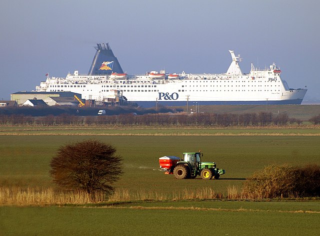
Fertiliser, Farming and Ferry,
Paull
,
East Riding of Yorkshire
, England.
A farmer distributes fertiliser from the back of his John Deere tractor on farmland north of Newton Garth near to the Hedon to Paull road early in the morning. At the same time, North Sea Ferry Pride of York passes on the River Humber just before it berths up outside of King George Dock in Hull. Towards the stern of the boat can be seen Paull Shipyard where a sea-going tug is being built – it is dwarfed by the ferry behind it! The embankment on the side of the Humber hides the river itself, so the ferry looks like a field object in its own right! As a telephoto lens was used for the photograph, the tractor seems to be close to the ferry, but the latter in reality, is well over a mile behind it! The photo was taken from Hedon Flyover |
| Date | |
| Source | From geograph.org.uk |
| Author | Andy Beecroft |
|
Permission
( Reusing this file ) |
Creative Commons Attribution Share-alike license 2.0 |
|
Attribution
( required by the license ) |
Andy Beecroft / Fertiliser, Farming and Ferry / |
| Camera location |
|
View this and other nearby images on: OpenStreetMap |
|
|---|
Licensing

|
This image was taken from the
Geograph project
collection. See
this photograph's page
on the Geograph website for the photographer's contact details. The copyright on this image is owned by
Andy Beecroft
and is licensed for reuse under the
Creative Commons
Attribution-ShareAlike 2.0 license.
|
This file is licensed under the
Creative Commons
Attribution-Share Alike 2.0 Generic
license.
Attribution:
Andy Beecroft
-
You are free:
- to share – to copy, distribute and transmit the work
- to remix – to adapt the work
-
Under the following conditions:
- attribution – You must give appropriate credit, provide a link to the license, and indicate if changes were made. You may do so in any reasonable manner, but not in any way that suggests the licensor endorses you or your use.
- share alike – If you remix, transform, or build upon the material, you must distribute your contributions under the same or compatible license as the original.