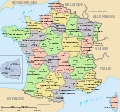
France_departements_regions_narrow.jpg

No higher resolution available.
| Description | Map of official départements and régions of France, with French titles (in JPEG format for larger, rapid display: 5x faster than SVG). French: Départements et régions, en Francais. | ||
| Date | |||
| Source | Image:Départements+régions (France).svg (Wikimedia file, converted to quick JPEG and narrowed 15%) | ||
| Author | self (after User:Historicair 6-Nov-2006) | ||
|
Permission
( Reusing this file ) |
|
||
| Other versions | Wider view, large 254kb SVG file: Image:Départements+régions (France).svg |

|
File:Départements+régions (France).svg
is a vector version of this file. It should be used in place of this JPG file.
File:France departements regions narrow.jpg →
File:Départements+régions (France).svg
For more information, see
Help:SVG
.
|
.svg)
|
Variations
-
 CURRENT IMAGE: Départements 520px (15% magnified, rapid JPEG format)
 -
 Départements 588px ( régions en lettres et colorisé , wider view, same labels, SVG format 5x slower)
 -
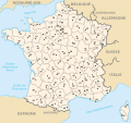 Départements sans colorisé (numeric labels, uncolorized)
 -
 Départements de France avec un découpage régional


