Fuerstabtei_St_Gallen.png

Size of this preview:
800 × 585 pixels
.
Other resolutions:
320 × 234 pixels
|
640 × 468 pixels
|
1,024 × 748 pixels
|
1,280 × 935 pixels
|
1,600 × 1,169 pixels
.
| Description |
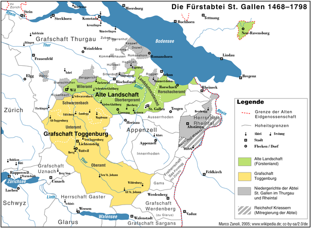
English:
The territories of the
Prince-Abbey of Saint Gall
, 1468–1798, without the exclaves near Freiburg im Breisgau.
The Abbey of Saint Gall exercised full sovereignty over the areas in green and yellow but only limited jurisdiction over the areas in grey.
Deutsch:
Das Territorium der
Fürstabtei St. Gallen
1468–1798, es fehlen die Exklaven bei Freiburg im Breisgau
|
| Date | |
| Source | Historischer Atlas der Schweiz. Hg. von Hektor Ammann und Karl Schib. Sauerländer: Aarau, 1958. |
| Author | Marco Zanoli ( sidonius ( talk ) 19:47, 27 January 2019 (UTC)) |
|
You may use my work outside wikipedia for free as long as you name me as the author. If you would like to use my work in a print medium, please send me a specimen copy.
Contact me if you have questions regarding the license or if you want individual changes to the map (marco.zanoli at hotmail.ch).
This file is licensed under the
Creative Commons
Attribution-Share Alike 4.0 International
license.
Attribution:
Marco Zanoli
|