Gaelic_Games_County_Map.svg

Size of this PNG preview of this SVG file:
424 × 600 pixels
.
Other resolutions:
170 × 240 pixels
|
339 × 480 pixels
|
543 × 768 pixels
|
724 × 1,024 pixels
|
1,448 × 2,048 pixels
|
744 × 1,052 pixels
.
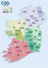
| Description | Counties contesting the All-Ireland Senior Football Championship (yellow), All-Ireland Senior Hurling Championship (blue), or both (green) |
| Date | (UTC) |
| Source | |
| Author |
|
|
|
This is a
retouched picture
, which means that it has been digitally altered from its original version. Modifications:
Altered colours of counties and legend
. The original can be viewed here:
Population density of Ireland map2002.svg
:
|
I, the copyright holder of this work, hereby publish it under the following license:
|
|
I, the copyright holder of this work, release this work into the
public domain
. This applies worldwide.
In some countries this may not be legally possible; if so: I grant anyone the right to use this work for any purpose , without any conditions, unless such conditions are required by law. |
Original upload log
This image is a derivative work of the following images:
-
File:Population_density_of_Ireland_map2002.svg
licensed with PD-self
- 2009-10-17T14:30:14Z The Illusional Ministry 800x1000 (635831 Bytes) Dublin now in black text
- 2009-10-17T14:27:13Z The Illusional Ministry 800x1000 (636262 Bytes) {{Information |Description=Map of Ireland's population density (people per km2). Based upon Republic of Ireland - 2002 Census results. |Source=*[[:File:Ireland_complete.svg|]] |Date=2009-10-17 14:25 (UTC) |Author=*[[:File:Ire
Uploaded with derivativeFX