Germany_topo_Fulda_Gap.jpg


Description
English: 
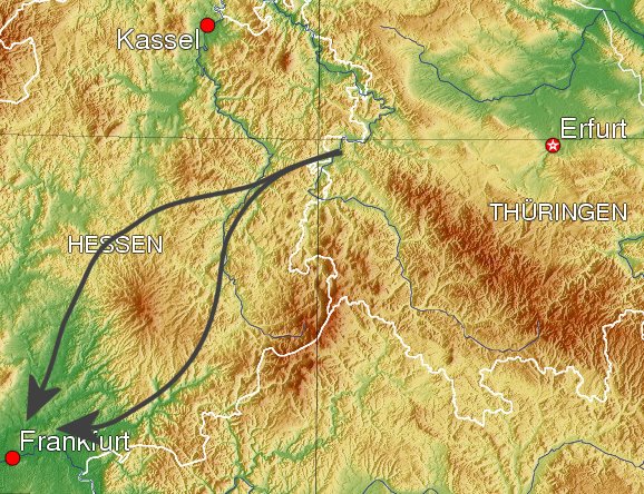
View of Germany. Arrows indicate theoretical vectors of attack via the Fulda Gap. Southern vector via town of Fulda, Northern via Bad Hersfeld, both are part of the Fulda Gap.
Date 4 August 2006, 03:47 (UTC)
Source Own derivative of Image:Germany topo.jpg
Author Dual Freq
Permission
( Reusing this file )

বাংলা English español français italiano 日本語 македонски sicilianu 中文(简体) 中文(繁體) +/−

GNU head Permission is granted to copy, distribute and/or modify this document under the terms of the GNU Free Documentation License , Version 1.2 or any later version published by the Free Software Foundation ; with no Invariant Sections, no Front-Cover Texts, and no Back-Cover Texts. A copy of the license is included in the section entitled GNU Free Documentation License .
w:en:Creative Commons
attribution share alike
This file is licensed under the Creative Commons Attribution-Share Alike 3.0 Unported license.
You are free:
  • to share – to copy, distribute and transmit the work
  • to remix – to adapt the work
Under the following conditions:
  • attribution – You must give appropriate credit, provide a link to the license, and indicate if changes were made. You may do so in any reasonable manner, but not in any way that suggests the licensor endorses you or your use.
  • share alike – If you remix, transform, or build upon the material, you must distribute your contributions under the same or compatible license as the original.
This licensing tag was added to this file as part of the GFDL licensing update .
Other versions Cropped version of Image:Germany topo.jpg

Captions

Add a one-line explanation of what this file represents

Items portrayed in this file

depicts

4 August 2006