Getting_UK_aid_to_those_who_need_it_most_(8511071806).jpg

Size of this preview:
800 × 530 pixels
.
Other resolutions:
320 × 212 pixels
|
640 × 424 pixels
|
1,024 × 678 pixels
|
1,280 × 848 pixels
|
2,560 × 1,696 pixels
|
4,928 × 3,264 pixels
.
Summary
| Description |
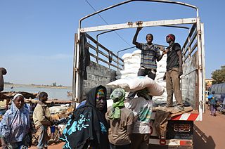
UK food aid is also reaching thousands of people in conflict-affected areas in central and northern Mali as well. Here, sacks of UK-funded rice are being transported by WFP from the central river port of Mopti to the northern town of Timbuktu and beyond. Although security continues to challenge many humanitarian agencies responding in northern Mali, WFP has undertaken food deliveries to the Timbuktu region, up the river Niger, for more than 100,000 people. Distributions are ongoing in Timbuktu and four surrounding districts, with the potential for further food deliveries to take place by road in the coming days. Photo © Daouda Guirou/WFP |
| Date | |
| Source | Getting UK aid to those who need it most |
| Author | DFID - UK Department for International Development |
| Camera location |
|
View this and other nearby images on: OpenStreetMap |
|
|---|
.jpg¶ms=014.493300_N_-004.194159_E_globe:Earth_type:camera_source:Flickr_&language=en)
Licensing
This file is licensed under the
Creative Commons
Attribution 2.0 Generic
license.
-
You are free:
- to share – to copy, distribute and transmit the work
- to remix – to adapt the work
-
Under the following conditions:
- attribution – You must give appropriate credit, provide a link to the license, and indicate if changes were made. You may do so in any reasonable manner, but not in any way that suggests the licensor endorses you or your use.
|
|
This image, originally posted to Flickr , was reviewed on 22 May 2013 by the administrator or reviewer File Upload Bot (Magnus Manske) , who confirmed that it was available on Flickr under the stated license on that date. |

|
The categories of this image need checking. You can do so
here
.
|
.jpg&action=edit&withJS=MediaWiki:Catcheck.js)