Great_Revolt_Normandy_1173.png
No higher resolution available.
Summary
| Description |
English:
Blank topographic map of
France
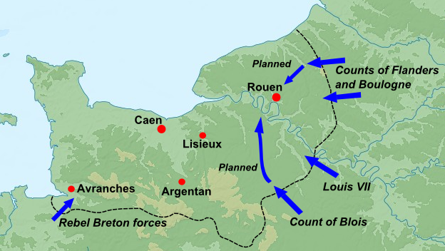
in the official Lambert-93 projection, with details of Normandy campaign in 1205 overlaid, information from Warren "King John", p.98.
Note: The background map is a raster image embedded in the SVG file.
Français :
Carte topographique vierge de la
France
suivant la projection officielle Lambert-93.
Note : Le fond de carte est une image bitmap embarquée dans le fichier SVG. Lambert-93 projection ; RGF-93 datum Scales: *Topography: 1:2,490,000 (precision 623 m) *Bathymetry: 1:7,640,000 (precision 1,910 m) |
| Date | (UTC) |
| Source | |
| Author |
|
|
|
This is a
retouched picture
, which means that it has been digitally altered from its original version. Modifications:
Map changed to show summer 1173
. The original can be viewed here:
Normandy campaign 1204.png
:
|
New military data set from Warren (2000), Henry II, p.126
Licensing
I, the copyright holder of this work, hereby publish it under the following licenses:
This file is licensed under the
Creative Commons
Attribution-Share Alike
3.0 Unported
,
2.5 Generic
,
2.0 Generic
and
1.0 Generic
license.
-
You are free:
- to share – to copy, distribute and transmit the work
- to remix – to adapt the work
-
Under the following conditions:
- attribution – You must give appropriate credit, provide a link to the license, and indicate if changes were made. You may do so in any reasonable manner, but not in any way that suggests the licensor endorses you or your use.
- share alike – If you remix, transform, or build upon the material, you must distribute your contributions under the same or compatible license as the original.

|
Permission is granted to copy, distribute and/or modify this document under the terms of the GNU Free Documentation License , Version 1.2 or any later version published by the Free Software Foundation ; with no Invariant Sections, no Front-Cover Texts, and no Back-Cover Texts. A copy of the license is included in the section entitled GNU Free Documentation License . |
You may select the license of your choice.
Original upload log
This image is a derivative work of the following images:
-
File:Normandy_campaign_1204.png
licensed with Cc-by-sa-3.0,2.5,2.0,1.0, GFDL
- 2011-01-03T09:31:13Z Hchc2009 522x327 (241049 Bytes) Arrows curved
- 2011-01-01T23:39:56Z Hchc2009 557x334 (261396 Bytes) Text made bigger
- 2011-01-01T23:25:36Z Hchc2009 515x352 (254847 Bytes) {{Information |Description={{en|Blank topographic map of [[:en:France|France]] in the official Lambert-93 projection.''Note:'' The background map is a raster image embedded in the SVG file.}} {{fr|Carte topographique vierge d
Uploaded with derivativeFX