Greatvalley-map.png

Size of this preview:
587 × 599 pixels
.
Other resolutions:
235 × 240 pixels
|
624 × 637 pixels
.


|
This
map
image could be re-created
using
vector graphics
as an
SVG
file
. This has several advantages; see
Commons:Media for cleanup
for more information. If an SVG form of this image is available, please upload it and afterwards replace this template with
{{

vector version available

|

new image name

}}
.
It is recommended to name the SVG file “Greatvalley-map.svg”—then the template Vector version available (or Vva ) does not need the new image name parameter. |
Summary
| Description |
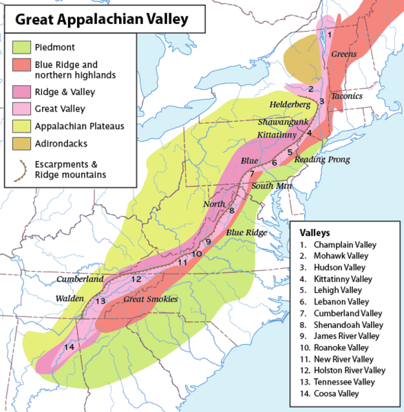
Map of the Appalachian Mountain physiographic regions, highlighting the Great Appalachian Valley, naming the main valleys making it up and the main mountains on either side. Legend:
|
| Date | (UTC) |
| Source | |
| Author |
|
|
|
This is a
retouched picture
, which means that it has been digitally altered from its original version. Modifications:
converted loselessto PNG
. The original can be viewed here:
Greatvalley-map.jpg
:
|
I, the copyright holder of this work, hereby publish it under the following license:
This file is licensed under the
Creative Commons
Attribution-Share Alike 2.5 Generic
license.
-
You are free:
- to share – to copy, distribute and transmit the work
- to remix – to adapt the work
-
Under the following conditions:
- attribution – You must give appropriate credit, provide a link to the license, and indicate if changes were made. You may do so in any reasonable manner, but not in any way that suggests the licensor endorses you or your use.
- share alike – If you remix, transform, or build upon the material, you must distribute your contributions under the same or compatible license as the original.
Original upload log
This image is a derivative work of the following images:
-
File:Greatvalley-map.jpg
licensed with Cc-by-sa-2.5
- 2006-11-14T06:22:37Z Pfly 624x637 (394372 Bytes) {{Information |Description=Map of the Appalachian Mountain physiographic regions, highlighting the Great Appalachian Valley, naming the main valleys making it up and the main mountains on either side. |Source=I made this map
Uploaded with derivativeFX