High_Asia_Mountain_Ranges.jpg

Size of this preview:
763 × 600 pixels
.
Other resolutions:
306 × 240 pixels
|
611 × 480 pixels
|
978 × 768 pixels
|
1,280 × 1,006 pixels
|
2,560 × 2,011 pixels
|
5,600 × 4,400 pixels
.
Summary
| Description |
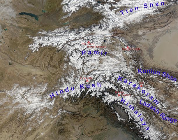
English:
high Asian mountain ranges and their highest mountains:
Deutsch:
Die innerasiatischen Hochgebirge:
|
| Date | (UTC) |
| Source |
This file was derived from:
Hindu Kush satellite image.jpg
:
|
| Author |
|
|
|
This is a
retouched picture
, which means that it has been digitally altered from its original version. Modifications:
mountain ranges (and highest mountains) labelled
. The original can be viewed here:
Hindu Kush satellite image.jpg
:
|
Licensing
|
|
This file is in the public domain in the United States because it was solely created by NASA . NASA copyright policy states that "NASA material is not protected by copyright unless noted ". (See Template:PD-USGov , NASA copyright policy page or JPL Image Use Policy .) |
|

|
Warnings:
|
Original upload log
This image is a derivative work of the following images:
-
File:Hindu_Kush_satellite_image.jpg
licensed with PD-USGov-NASA
- 2006-06-06T04:39:19Z Avenue 5600x4400 (5255682 Bytes) {{Information |Description=The Hindu Kush occupies the lower-left-center of this true-color MODIS satellite image, acquired 28 November 2003. |Source=[NASA's Earth Observatory http://earthobservatory.nasa.gov/Newsroom/NewImag
Uploaded with derivativeFX