Himalayas.jpg
Size of this preview:
800 × 527 pixels
.
Other resolutions:
320 × 211 pixels
|
640 × 422 pixels
|
1,024 × 675 pixels
|
1,280 × 843 pixels
|
3,032 × 1,998 pixels
.
Summary
| Description |
Deutsch:
Der Himalaya von oben gesehen
English:
Himalaya from the
International Space Station
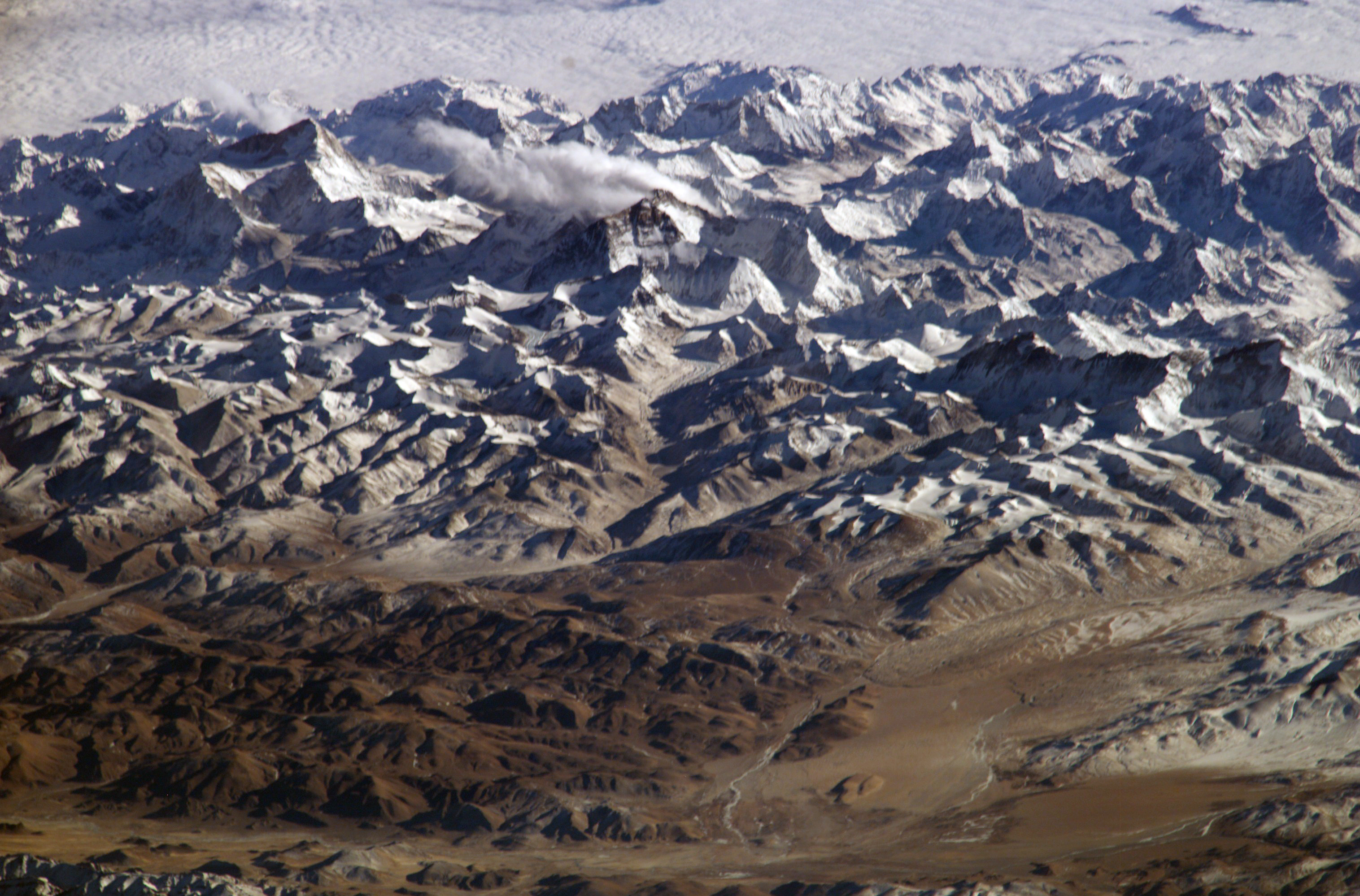
. In addition to looking heavenward, NASA helps the world see the Earth in ways no one else can. Astronauts on board the International Space Station recently took advantage of their unique vantage point to photograph the Himalayas, looking south from over the Tibetan Plateau. The perspective is illustrated by the summits of Makalu [left (8,462 metres; 27,765 feet)], Everest [middle (8,848 metres; 29,035 feet)] , Lhotse [middle (8,516 metres; 27,939 feet)] and Cho Oyu [right (8,201 metres; 26,906 feet)] -- at the heights typically flown by commercial aircraft.
Español:
El
Himalaya
visto desde la
Estación Espacial Internacional
. La planicie tibetana en primer término. Se pueden apreciar las cumbres de
Makalu
(8 462 metres, en la izquierda), de el
Everest
(8 848 m, en el centro), el
Lhotse
(justo a la derecha del Everest, 8516 m) y el
Cho Oyu
(a la derecha del todo, 8 201 m de altitud).
Français :
L'
Himalaya
vu de la
Station spatiale internationale
. La NASA ne fait pas que regarder les étoiles, mais utilise aussi ses points de vues uniques pour observer la terre. Cette vue de l’Himalaya a été prise depuis la Station spatiale internationale, avec le plateau tibétain au premier plan. On peut voir les sommets du
Makalu
(8 462 mètres, à gauche), de l'
Everest
(8 848 m, au milieu), du
Lhotse
(juste à droite de l'Everest, 8516 m) et du
Cho Oyu
(tout à droite, 8 201 m d'altitude). L'altitude de ces sommets correspond aux altitudes de vol des avions de ligne.
Suomi:
Himalaja kansainväliseltä avaruusasemalta kuvattuna
日本語:
国際宇宙ステーションから撮影したヒマラヤ山脈。チベット高原から南方を見た時の図。エベレストが中央付近に見える。
Italiano:
L'Himalaya fotografata dalla
stazione spaziale internazionale
, con l'altopiano del Tibet in primo piano. Si possono notare le cime dei monti
Makalu
(8462 metri, in alto a sinistra),
Everest
(8848 metri, in centro),
Lhotse
(8516 metri, appena sopra l'Everest sulla foto) e
Cho Oyu
(8201 metri, a destra). Queste altezze corrispondono a quelle raggiunte dagli aerei di linea.
中文:
從國際太空站上拍攝的喜瑪拉雅山脈照片。除了往天空方向觀看喜瑪拉雅山之外,美國太空總署協助世人從一個普通人無法達成的角度拍攝了喜瑪拉雅山脈。國際太空站上的太空人利用了他們特殊的優勢拍攝了這張照片。這張照片的角度是從西藏高原往南看的。
|
| Date | January 28, 2004, 10:01:59 GMT |
| Source |
http://www.nasa.gov/multimedia/imagegallery/image_feature_152.html
|
| Author | NASA |
| Other versions |

|
|
|
This image or video was catalogued by one of the centers of the United States
National Aeronautics and Space Administration
(NASA) under
Photo ID:
ISS008-E-13304
.
This tag does not indicate the copyright status of the attached work. A normal copyright tag is still required. See Commons:Licensing .
Other languages:
|
Assessment
|
|
|
This image was selected as
picture of the day
on Wikimedia Commons for
16 September 2005
. It was captioned as follows:
Other languages:
|
|
|
Deutsch:
Dieses Bild war 2009 in der 39. Kalenderwoche das
Bild der Woche
in der
Malaysischen Wikipedia
English:
This image was selected as a
picture of the week
on the
Malay Wikipedia
for the 39
th
week, 2009.
Македонски:
Сликава е избрана за
слика на неделата
на
малајската Википедија
за XXXIX недела од 2009 година.
Bahasa Melayu:
Imej ini merupakan
gambar pilihan mingguan
di
Wikipedia Bahasa Melayu
untuk minggu ke-39, 2009.
Français :
Cette image est sélectionnée en tant qu'
image de la semaine
sur la
Wikipédia Malaisienne
pour la 39ème semaine de 2009.
Italiano:
Questa immagine è stata selezionata come
Immagine della settimana
su
Wikipedia in malese
per la XXXIX settimana del 2009.
Nederlands:
Deze afbeelding is gekozen als
afbeelding van de week
op de
Maleisische Wikipedia
voor week 39 van 2009.
Русский:
Эта иллюстрация была выбрана
изображением недели
в
малайском разделе «Википедии»
для недели номер 39 2009 года.
Українська:
Ця ілюстрація була вибрана
зображенням тижня
в
малайському розділі «Вікіпедії»
для тижня номер 39, 2009 року.
Tiếng Việt:
Hình này đã được chọn làm
hình ảnh của tuần
trên
Wikipedia tiếng Mã Lai
trong tuần thứ 39, năm 2009.
|
|
Licensing
|
|
This file is in the
public domain
in the United States because it was created by the Image Science & Analysis Laboratory, of the
NASA
Johnson Space Center. NASA copyright policy states that "NASA material is not protected by copyright
unless noted
". (
NASA media use guidelines
or
Conditions of Use of Astronaut Photographs
).
Photo source:
ISS008-E-13304
.
|
| Annotations | This image is annotated: View the annotations at Commons |