|
Description
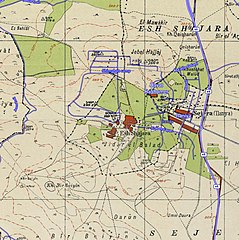
Historical map series for the area of al-Shajara, Tiberias (1940s with modern overlay).jpg
|
A 1940s map of the area of
al-Shajara, Tiberias
from the
Survey of Palestine
overlaid with modern roads. This map is part of a series of historical maps used for comparison, showing the same area, made with help from
Palestine Open Maps
. Related files include:
|
Permission
(
Reusing this file
)
|
Copyright for the OpenStreetMap data

|
|
This work contains information from
OpenStreetMap
, which is made available under the
Open Database License (ODbL)
.
The ODbL does not require any particular license for maps produced from ODbL data. Prior to 1 August 2020, map tiles produced by the OpenStreetMap Foundation were licensed under the
CC-BY-SA-2.0 license
. Maps produced by other people may be subject to other licences.
Open Database License
ODbL
http://opendatacommons.org/licenses/odbl/1.0/
true
|
Copyright for the Survey of Palestine and PEF Survey maps:
|
Public domain
Public domain
false
false
|
|
Public domain
Public domain
false
false
|

|
This work was created or ordered by the State of Israel, and is in the
public domain
because it satisfies one of the conditions stipulated in
Israel's copyright statute from 2007
(
translation
) regarding the State's copyrights:
-
It is a statute, regulation, Knesset protocol or court decision and therefore ineligible for copyright protection according to §6 of the 2007 statute; OR
-
It was created more than 50 years ago (
i.e.
before 1 January 1974), and the State's copyright has therefore expired according to §§42–43 of the 2007 statute PROVIDING THAT
-
-
The State of Israel was the first owner of copyrights on this work; AND
-
The State did not waive its copyrights in a special contract with the author when this work was created.
English
∙
русский
∙
中文
∙
हिन्दी
∙
עברית
∙
العربية
∙
+/−
|

|
|

.jpg)
.jpg)
.jpg)

.jpg¶ms=032.754444_N_0035.398889_E_globe:Earth_type:camera__&language=en)