Holy_Alliance.png
No higher resolution available.

|
File:Map of the Holy Alliance (1840).svg
is a vector version of this file. It should be used in place of this PNG file when not inferior.
File:Holy Alliance.png →
File:Map of the Holy Alliance (1840).svg
For more information, see
Help:SVG
.
|
.svg)
|
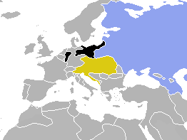
| Description | Map of Europe, highlighting the Holy Alliance of 1815 | ||
| Date | (UTC) | ||
| Source | Cropped and colourised from Image:BlankMap-World-1840.png | ||
| Author | OwenBlacker | ||
|
Permission
( Reusing this file ) |
|