Hungary_in_1941_with_territories_annexed_in_1938-1941.png

Size of this preview:
800 × 578 pixels
.
Other resolutions:
320 × 231 pixels
|
640 × 462 pixels
|
1,022 × 738 pixels
.
| Description |
English:
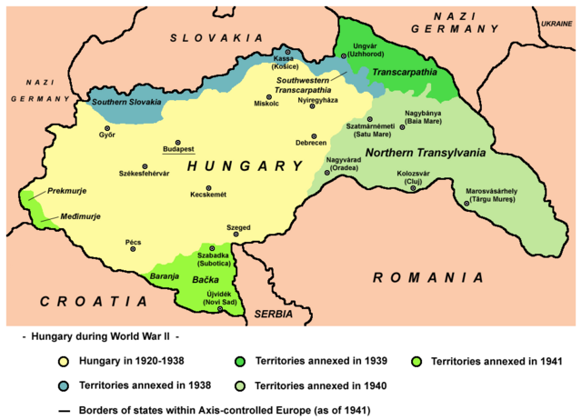
Map of territories annexed by Hungary in 1938-1941.
|
||
| Date | |||
| Source | Own work - derivative work; modified version of this map whose author was User:PANONIAN : File:Hungary map.png . | ||
| Author | Mixx321 | ||
|
Permission
( Reusing this file ) |
I, the copyright holder of this work, hereby publish it under the following license:
|

References
- The Times History of Europe, Times Books, London, 2002
- Richard Overy, The Times History of the 20th Century, Times Books, London, 2004.
- Peter Rokai - Zoltan Đere - Tibor Pal - Aleksandar Kasaš, Istorija Mađara, Beograd, 2002.
- http://terkepek.adatbank.transindex.ro/kepek/netre/224.gif
- http://www.hunmagyar.org/tor/terkep.jpg
- http://www.map.hu/galeria/orig/1426_hu_in_maps_fig_12_states_1648-2009.jpg archive copy at the Wayback Machine
- http://magyar.files.wordpress.com/2006/07/11399032041.JPG?w=440&h=343
- http://crowland.uw.hu/images/csata/delvidek_02.jpg archive copy at the Wayback Machine
- http://www.conflicts.rem33.com/images/Ungarn/hunhist_V_files/image004.jpg