IndianRailways1871b.jpg

Size of this preview:
458 × 599 pixels
.
Other resolutions:
183 × 240 pixels
|
367 × 480 pixels
|
1,018 × 1,331 pixels
.
Summary
| Description |
English:
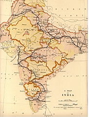
Map of Indian Railways in 1871 prepared by the British Government
India Office
for the House of Commons Committee.
|
|||||||||
| Date | ||||||||||
| Source | Scanned reduced and uploaded from personal copy by Fowler&fowler «Talk» 00:53, 15 November 2009 (UTC). Transferred from en.wikipedia ; transferred to Commons by User:Innotata using CommonsHelper . | |||||||||
| Creator |
Saunders Geographers
|
|||||||||
| Geotemporal data | ||||||||||
| Bounding box |
|
|||||||||
| Georeferencing | ||||||||||
Licensing
|
|
This work
created by the United Kingdom Government
is in the
public domain
.
This is because it is one of the following :
HMSO has declared that the expiry of Crown Copyrights applies worldwide (ref:
HMSO Email Reply
)
|

|
Original upload log
The original description page was
here
. All following user names refer to en.wikipedia.
- 2009-11-15 00:53 Fowler&fowler 1018×1331× (999532 bytes) {{Information |Description = Map of Indian Railways in 1871 prepared by the British Government [[India Office]] for the House of Commons Committee. |Source = UK Government India Office Map (personal copy) |Date = 1871 |Author