Indonesia_2002_CIA_map.png

Size of this preview:
800 × 535 pixels
.
Other resolutions:
320 × 214 pixels
|
640 × 428 pixels
|
1,024 × 685 pixels
|
1,280 × 857 pixels
|
2,690 × 1,800 pixels
.
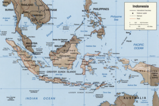
Indonesia.
United States. Central Intelligence Agency.
CREATED/PUBLISHED [Washington, D.C. : Central Intelligence Agency, 2002]
NOTES Relief shown by shading.
"Base 802899AI (C00429) 11-02."
Also issued without shaded relief.
Scale [ca. 1:25,000,000] ; Mercator proj. (E 1040--E 1430/N 170--S 150).
SUBJECTS Indonesia--Maps. Indonesia.
MEDIUM 1 map : col. ; 16 x 23 cm.
CALL NUMBER G8070 2002 .U6
REPOSITORY Library of Congress Geography and Map Division Washington, D.C. 20540-4650 USA
DIGITAL ID g8070 ct000982 http://hdl.loc.gov/loc.gmd/g8070.ct000982
|
|
This image is a work of a
Central Intelligence Agency
employee, taken or made as part of that person's official duties. As a Work of the United States Government, this image or media is in the
public domain
in the United States.
|

|
Other versions: Image:Indonesia 2002 CIA map.jpg , File:Indonesia 2002 CIA map-ar.png