Jylland_Fjorder_SH_Förden.png

Size of this preview:
193 × 597 pixels
.
Other resolutions:
77 × 240 pixels
|
155 × 480 pixels
|
816 × 2,524 pixels
.
Summary
| Description |
English:
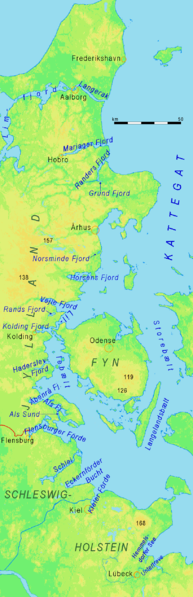
Eastern coast of the Cimbrian Peninsula: Fjords of Schleswig-Holstein and eastern Jylland. All land shown on this map is located less than 200 meters above sea level.
Deutsch:
Ostküste der Cimbrischen Halbinsel: Förden Schleswig-Holsteins und fördenartige Fjorde Ostjütlands. Vorsicht mit den Höhenfarben: Alles Land auf dieser Karte liegt weniger als 200 m über NN.
|
| Source | http://www.maps-for-free.com |
| Author | Ulamm 21:07, 5 February 2008 (UTC) |
Licensing
This file is licensed under the
Creative Commons
Attribution-Share Alike 3.0 Unported
license.
-
You are free:
- to share – to copy, distribute and transmit the work
- to remix – to adapt the work
-
Under the following conditions:
- attribution – You must give appropriate credit, provide a link to the license, and indicate if changes were made. You may do so in any reasonable manner, but not in any way that suggests the licensor endorses you or your use.
- share alike – If you remix, transform, or build upon the material, you must distribute your contributions under the same or compatible license as the original.