KKH.png

Size of this preview:
419 × 599 pixels
.
Other resolutions:
168 × 240 pixels
|
595 × 851 pixels
.

|
This file requires updating because:
Bulungkol
is shown on this map but not labeled; it should be labeled. Also, the
China-Tajikistan border
has changed.
In doing so, you could add a timestamp to the file.
|
Summary
| Description |
English:
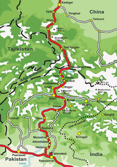
This is a map of
Karakoram Highway
, the
road
that links the
Northern Areas
of
Pakistan
to the
Xinjiang
province of
China
, connecting it to the old
Silk Road
.
|
| Source | Own work by the original uploader |
| Author | de:Benutzer:Grag , User:Tevatron~commonswiki , User:Lexicon |
| Other versions |

.png)
|

|
This
road map
image could be re-created
using
vector graphics
as an
SVG
file
. This has several advantages; see
Commons:Media for cleanup
for more information. If an SVG form of this image is available, please upload it and afterwards replace this template with
{{

vector version available

|

new image name

}}
.
It is recommended to name the SVG file “KKH.svg”—then the template Vector version available (or Vva ) does not need the new image name parameter. |
Licensing

|
Permission is granted to copy, distribute and/or modify this document under the terms of the GNU Free Documentation License , Version 1.2 or any later version published by the Free Software Foundation ; with no Invariant Sections, no Front-Cover Texts, and no Back-Cover Texts. A copy of the license is included in the section entitled GNU Free Documentation License . |
|
|
This file is licensed under the Creative Commons Attribution-Share Alike 3.0 Unported license. | |
|
||
| This licensing tag was added to this file as part of the GFDL licensing update . |