Karta_PG_Trobriand_isl.PNG
No higher resolution available.
Summary
| Description |
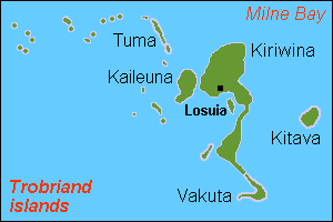
English:
Map (rough) of Trobriand islands, Papua New Guinea, own work composed from various mapreferences
|
| Date | |
| Source | Own work |
| Author | Hobe / Holger Behr |
Licensing
|
|
I, the copyright holder of this work, release this work into the
public domain
. This applies worldwide.
In some countries this may not be legally possible; if so: I grant anyone the right to use this work for any purpose , without any conditions, unless such conditions are required by law. |