Kashmir_map_big.jpg


Pir gali shahdra Sharif

Summary

Description
English: 
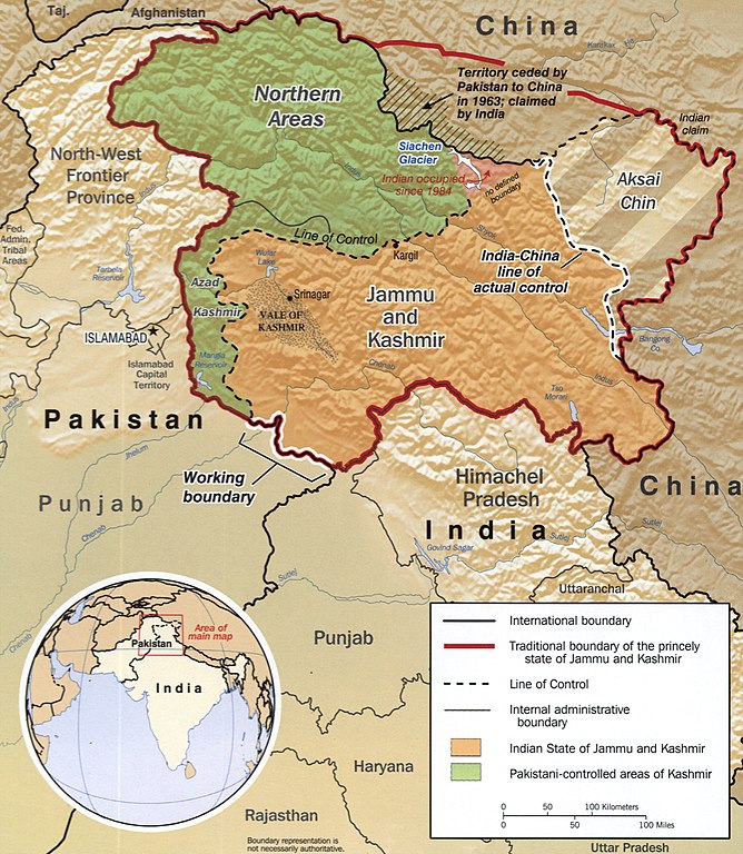
The disputed area of Kashmir.
  • Notes
"760279AI (R00744) 6-02."
Relief shown by shading.
Includes location map.
  • Medium
1 map : col. ; 20 x 17 cm.
  • Call Number
G7653.J3F2 2002 .U5
  • Control Number
2002626371
  • Digital ID
g7653j ct000803 http://hdl.loc.gov/loc.gmd/g7653j.ct000803
Date CREATED/PUBLISHED
Source
This map is available from the United States Library of Congress 's Geography & Map Division
under the digital ID g7653j.ct000803 .
This tag does not indicate the copyright status of the attached work. A normal copyright tag is still required. See Commons:Licensing .

العربية беларуская (тарашкевіца) বাংলা čeština Deutsch English español فارسی suomi français galego עברית magyar Bahasa Indonesia italiano 日本語 lietuvių македонски മലയാളം Nederlands polski português português do Brasil română русский sicilianu slovenčina slovenščina Türkçe українська 简体中文 繁體中文 +/−

Library of Congress Geography and Map Division Washington, D.C. 20540-4650 USA
Author Central Intelligence Agency, Washington, 2002

Licensing

Public domain This image is a work of a Central Intelligence Agency employee, taken or made as part of that person's official duties. As a Work of the United States Government, this image or media is in the public domain in the United States.

čeština Deutsch eesti English español français italiano português polski sicilianu slovenščina suomi Tiếng Việt български македонски русский українська বাংলা മലയാളം 한국어 日本語 中文 中文(简体) 中文(繁體) العربية پښتو +/−

Old file history

taken from de.wiki there under PD with description

Captions

Add a one-line explanation of what this file represents

Items portrayed in this file

depicts

image/jpeg