Kinder_upfall.jpg

Size of this preview:
800 × 533 pixels
.
Other resolutions:
320 × 213 pixels
|
640 × 427 pixels
|
1,024 × 683 pixels
|
1,280 × 853 pixels
|
2,448 × 1,632 pixels
.
Summary
| Description |
English:
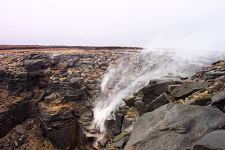
Kinder Downfall in strong west wind
|
| Date | 5 January 2009 (original upload date) |
| Source | Own work |
| Author | Dave59 at en.wikipedia |
| Camera location |
|
View this and other nearby images on: OpenStreetMap |
|
|---|
Licensing
Dave59
at
en.wikipedia
, the copyright holder of this work, hereby publishes it under the following license:
This file is licensed under the
Creative Commons
Attribution 3.0 Unported
license.
Attribution:
Dave59
at
en.wikipedia
-
You are free:
- to share – to copy, distribute and transmit the work
- to remix – to adapt the work
-
Under the following conditions:
- attribution – You must give appropriate credit, provide a link to the license, and indicate if changes were made. You may do so in any reasonable manner, but not in any way that suggests the licensor endorses you or your use.
Original upload log
The original description page was
here
. All following user names refer to en.wikipedia.
- 2009-01-05 14:18 Dave59 2448×1632× (3210011 bytes) Kinder Downfall in strong east wind. Taken by me.