Kingdom_of_the_Isles,_circa_1200_(png_version).png
No higher resolution available.
Summary
| Description |
English:
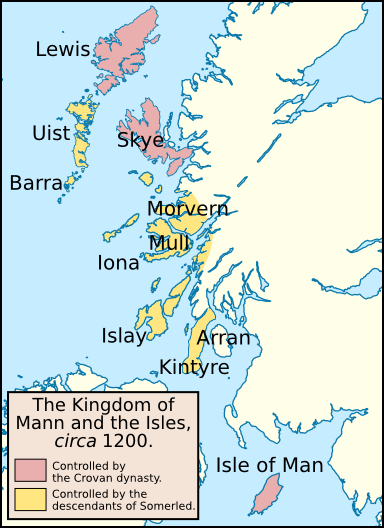
Map of the
Kingdom of the Isles
, circa 1200. I created this map using
Inkscape
. I used the following image to create this map:
File:United_Kingdom_location_map.svg
. I based this map off one published in: McDonald, R.A. (2007).
Manx Kingship in its Irish sea Setting, 1187–1229: King Rǫgnvaldr and the Crovan dynasty
. Four Courts Press. 978-1-84682-047-2.
|
| Date | |
| Source | Own work |
| Author | Brianann MacAmhlaidh |
| Other versions | File:Kingdom of the Isles, circa 1200.svg (SVG version). |
Licensing
I, the copyright holder of this work, hereby publish it under the following license:
This file is licensed under the
Creative Commons
Attribution-Share Alike 3.0 Unported
license.
-
You are free:
- to share – to copy, distribute and transmit the work
- to remix – to adapt the work
-
Under the following conditions:
- attribution – You must give appropriate credit, provide a link to the license, and indicate if changes were made. You may do so in any reasonable manner, but not in any way that suggests the licensor endorses you or your use.
- share alike – If you remix, transform, or build upon the material, you must distribute your contributions under the same or compatible license as the original.