La2-demis-gotland-ship-stone-settings.png
Size of this preview:
403 × 599 pixels
.
Other resolutions:
161 × 240 pixels
|
517 × 769 pixels
.
Summary
| Description |
English:
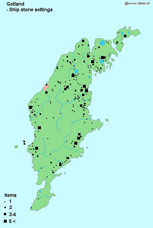
Stone ship settings in Gotland,
|
| Date | |
| Source |
This file was derived from:
La2-demis-gotland.png
:

|
| Author |
|
|
|
This is a
retouched picture
, which means that it has been digitally altered from its original version. Modifications:
Added stone ship settings distribution, archaeological data, source by Wehlin, Joakim: Approaching the Gotlandic Bronze Age from Sea., 2010, Gotland University Press
. The original can be viewed here:
La2-demis-gotland.png
:
|
Licensing
|
|
This image is in the
public domain
because it came from the site
https://www.demis.nl/products/web-map-server/examples/
and was released by the
copyright
holder. Permission is granted to copy, distribute and/or modify this map since it is based on free of copyright images from:
www.demis.nl
. See also
approval email on de.wp
and
its clarification
.
|
|
|
This work has been released into the
public domain
by its
copyright
holder,
www.demis.nl
. This applies worldwide.
In some countries this may not be legally possible; if so: www.demis.nl grants anyone the right to use this work for any purpose , without any conditions, unless such conditions are required by law.
|
Original upload log
This image is a derivative work of the following images:
- File:La2-demis-gotland.png licensed with PD-Demis
Uploaded with derivativeFX
}}