Labrador-fourpeaks-uwm.png
No higher resolution available.
Summary
| Description |
English:
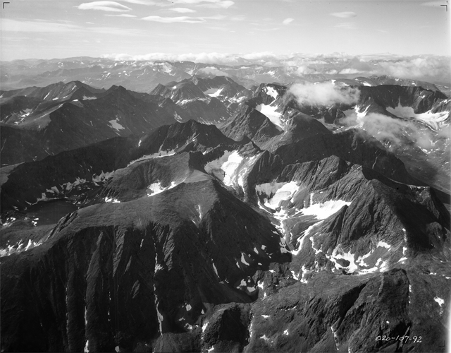
Fig. 65 - Looking southwest across the Four Peaks group of mountains which fills the foreground and middle distance. Note the maturely developed cirques, some of which are occupied by residual glaciers, and compare with the less advanced cirque cutting of the northern central range illustrated in Figure 81. Aug. 2, 1931.
|
| Date | |
| Source | American Geographical Society Library, University of Wisconsin-Milwaukee Libraries |
| Author | Forbes, Alexander, 1882-1965 |
|
Permission
( Reusing this file ) |
From the American Geographical Society Library, University of Wisconsin-Milwaukee Libraries |
Also published in Forbes, Alexander (1938), Northernmost Labrador mapped from the air, New York: American Geographical Society.
Licensing
This file is licensed under the
Creative Commons
Attribution-Share Alike 3.0 Unported
license.
-
You are free:
- to share – to copy, distribute and transmit the work
- to remix – to adapt the work
-
Under the following conditions:
- attribution – You must give appropriate credit, provide a link to the license, and indicate if changes were made. You may do so in any reasonable manner, but not in any way that suggests the licensor endorses you or your use.
- share alike – If you remix, transform, or build upon the material, you must distribute your contributions under the same or compatible license as the original.