Lancaster1610_-_St_Helins_Region.png
No higher resolution available.
Summary
| Description |
English:
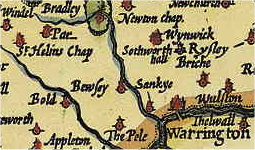
A splice of a 1610 Map showing the local region of Lancaster in 1610
|
| Date | (UTC) |
| Source | Own work |
| Author | Koncorde ( talk ) |
A derivative sample of a work now in Public Domain. Koncorde ( talk ) 18:04, 11 June 2010 (UTC)
|
|
This work is in the public domain in its country of origin and other countries and areas where the copyright term is the author's life plus 100 years or fewer . |
| This file has been identified as being free of known restrictions under copyright law, including all related and neighboring rights. | |
Original upload log
Transferred from en.wikipedia to Commons using FtCG .
The original description page was
here
. All following user names refer to en.wikipedia.
| Date/Time | Dimensions | User | Comment |
|---|---|---|---|
| 19:10, 14 June 2010 | 255 × 150 (89,832 bytes) | w:en:Koncorde ( talk | contribs ) | (Focused on relevant area more closely to fit article.~~~~) |
| 18:04, 11 June 2010 | 317 × 197 (148,036 bytes) | w:en:Koncorde ( talk | contribs ) | ({{Information |Description = A splice of a 1610 Map showing the local region of Lancaster in 1610 |Source = I (~~~) created this work entirely by myself. |Date = ~~~~~ |Author = ~~~ |other_versions = NIL }} A derivative ) |

|
The categories of this image need checking. You can do so
here
.
|