LocationNSAm2.png

Size of this preview:
600 × 600 pixels
.
Other resolutions:
240 × 240 pixels
|
480 × 480 pixels
.
Summary
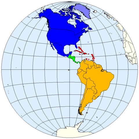
| Description | Division of the Americas into North, Central and South America and the West Indies. |
| Date | |
| Source | prepared from public domain maps created by w:en:User:E Pluribus Anthony . |
| Author | Spacepotato |
Legend
- 0000FF: North America.
- 8080FF: Sometimes included in North America.
- 00FF06: Central America.
- FF0000: West Indies.
- FFBA00: South America.
References
- MSN Encarta archive copy at the Wayback Machine , Microsoft. Accessed on line October 15, 2007. Divides the Western Hemisphere into North America, Central America, the West Indies, and South America.
- " North America archive copy at the Wayback Machine ". MSN Encarta , Microsoft. Accessed on line October 11, 2007. Defines North America as including Canada, the USA, Mexico, Greenland, St. Pierre and Miquelon, and Bermuda.
- " Central America archive copy at the Wayback Machine ". MSN Encarta , Microsoft. Accessed on line October 12, 2007. Defines Central America as including Belize, Costa Rica, El Salvador, Guatemala, Honduras, Nicaragua, and Panama.
Licensing
|
|
I, the copyright holder of this work, release this work into the
public domain
. This applies worldwide.
In some countries this may not be legally possible; if so: I grant anyone the right to use this work for any purpose , without any conditions, unless such conditions are required by law. |
See also
- Image:LocationNSAm.png
- Image:LocationNSAm3.png
- Image:LocationNSAngloLatin.png
- Image:LocationNSAmUNGeoscheme.png