Makoko_shule_ya_lugha_aussen.jpg


Summary

Description
Deutsch: 
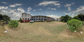
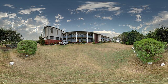
Kugelpanorama im Hof der Makoko Language School, Makoko, Musoma, Tansania
English: Panoramic of Makoko Language School in Makoko, Musoma, Tanzania
Date
Source Photo: Own work , Building: Brother John Damien Walsh MM (†)
Author Ikiwaner
Permission
( Reusing this file )
VRT Wikimedia

This work is free and may be used by anyone for any purpose. If you wish to use this content , you do not need to request permission as long as you follow any licensing requirements mentioned on this page.

The Wikimedia Foundation has received an e-mail confirming that the copyright holder has approved publication under the terms mentioned on this page. This correspondence has been reviewed by a Volunteer Response Team (VRT) member and stored in our permission archive . The correspondence is available to trusted volunteers as ticket #2010100110002396 .

If you have questions about the archived correspondence, please use the VRT noticeboard . Ticket link: https://ticket.wikimedia.org/otrs/index.pl?Action=AgentTicketZoom&TicketNumber=2010100110002396
Find other files from the same ticket: SDC query (SPARQL)

Camera location 1° 29′ 27.27″ S, 33° 45′ 58.7″ E Kartographer map based on OpenStreetMap. View this and other nearby images on: OpenStreetMap info
360°

Licensing

GNU head Permission is granted to copy, distribute and/or modify this document under the terms of the GNU Free Documentation License , Version 1.2 only as published by the Free Software Foundation ; with no Invariant Sections, no Front-Cover Texts, and no Back-Cover Texts. A copy of the license is included in the section entitled GNU Free Documentation License . 1.2 only

This image has been assessed using the Quality image guidelines and is considered a Quality image .

العربية جازايرية беларуская беларуская (тарашкевіца) български বাংলা català čeština Cymraeg Deutsch Schweizer Hochdeutsch Zazaki Ελληνικά English Esperanto español eesti euskara فارسی suomi français galego עברית हिन्दी hrvatski magyar հայերեն Bahasa Indonesia italiano 日本語 Jawa ქართული 한국어 kurdî Lëtzebuergesch lietuvių македонски മലയാളം मराठी Bahasa Melayu Nederlands Norfuk / Pitkern polski português português do Brasil rumantsch română русский sicilianu slovenčina slovenščina shqip српски / srpski svenska தமிழ் తెలుగు ไทย Tagalog Türkçe toki pona українська vèneto Tiếng Việt 中文 中文(简体) 中文(繁體) +/−

Captions

Add a one-line explanation of what this file represents

Items portrayed in this file

depicts

1°29'27.26999"S, 33°45'58.70016"E

7 September 2010