Manhattan_neighborhoods.png

Size of this preview:
506 × 599 pixels
.
Other resolutions:
203 × 240 pixels
|
405 × 480 pixels
|
649 × 768 pixels
|
865 × 1,024 pixels
|
2,000 × 2,368 pixels
.
Summary
| Description |
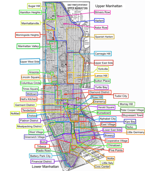
Approximate locations of some past and present neighborhoods as described on the articles on w:Template:Manhattan . Made from two 1920 public domain maps of Manhattan in the University of Texas collection, - base map here: Image:Manhattan 1920.png . Some of the neighborhoods are colored in two colors to show a narrow and broad definition, such as Gramercy. Not all of the names on the map itself are still current (such as "Little Italy" inside what is now Spanish Harlem, and Blackwell's Island, which is now Roosevelt Island). |
||
| Date | 28 November 2006 (original upload date) | ||
| Source | No machine-readable source provided. Own work assumed (based on copyright claims). | ||
| Author | No machine-readable author provided. Roke~commonswiki assumed (based on copyright claims). | ||
| Other versions |
|

Licensing
I, the copyright holder of this work, hereby publish it under the following license:

|
Permission is granted to copy, distribute and/or modify this document under the terms of the GNU Free Documentation License , Version 1.2 or any later version published by the Free Software Foundation ; with no Invariant Sections, no Front-Cover Texts, and no Back-Cover Texts. A copy of the license is included in the section entitled GNU Free Documentation License . |
|
|
This file is licensed under the Creative Commons Attribution-Share Alike 3.0 Unported license. | |
|
||
| This licensing tag was added to this file as part of the GFDL licensing update . |
derivative works
Derivative works of this file: Manhattan neighborhoods-2.png