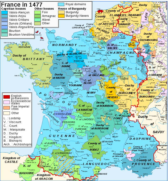
Map_France_1477-en.svg

Legends
Français : Légende
English: Legend
|
Red line: Boundary of the Kingdom of France
Capetian houses ( Valois , Bourbon ) :
Valois-Alençon
(
René of Alençon
) :
— Duchy of Alençon (1220) — County of Perche (1227)
Valois-Anjou
(
René I the Good
) :
— Duchy of Anjou (1204) — County of Provence (1498) — Duchy of Bar (1766) — County of Maine (1204) — County of Guise (1688) — County of Gien (1199) — Viscounty of Châtellerault (1482)
Valois-Orléans
(
Louis XII of France
) :
— Duchy of Orléans (987) — Duchy of Valois (1214)
Orléans-Dunois
(François d'Orléans-Longueville, son of
Jean de Dunois
) :
— County of Dunois (1707) — County of Longueville (13th century) — Lordship of Parthenay (1419)
Valois-Angoulême
(Charles d'Orléans) :
— County of Angoulême (1308)
Bourbon
(
John II, Duke of Bourbon
) :
— Duchy of Bourbon (1531) — Duchy of Auvergne (v. 1200) — County of Forez (1531) — County of Clermont-en-Beauvaisis (1218) — Lordship of Beaujeu (1531) |
Other houses :
House of Burgundy :
House of Burgundy
(
Charles the Rash
) :
— Duchy of Burgundy (1016) — County of Charolais (1751) — Sundgau (1648) — Picardy (12-13th centuries) — County of Artois (1185) — County of Hainaut (1659, 1678) — County of Flanders (1678) — Duchy of Brabant (-) — Duchy of Guelders (-)
House of Bourgogne-Nevers
(
John II of Burgundy-Nevers
) :
— County of Nevers (?) — County of Rethel (?) — County of Eu (?)
House of Foix
(
Francis Phoebus
) :
— County of Foix (1589) — County of Bigorre (1322) — Viscounty of Béarn (1589) — Kingdom of Navarre (1589) — Co-Princes of Andorra (-) John of Foix-Étampes, brother of Francis Phoebus : — Viscount of Narbonne (1507)
House of Armagnac
(
Charles I of Armagnac
) :
— County of Armagnac (1589) — County of Rodez (1589) — County of Marche (1531) — Duchy of Nemours (1274)
House of Albret
(
Alain d'Albret
) :
— Lordship of Albret (1589) — Viscounty of Limoges (1589) — County of Périgord (1589)
Various houses
:
House of Brittany ( Francis II, Duke of Brittany ) : — Duchy of Brittany (1532) — County of Vertus (1284?) House of Montpensier ( Louis I, Count of Montpensier , count of Montpensier et dauphin of Auvergne ) : — County of Sancerre (1234) House of Chalon ( John of Chalon-d'Arlay ) : — Principality of Orange (1673) House of Husson-Tonnerre (Charles de Husson) : — County of Tonnerre (?) House of Lorraine ( René II, Duke of Lorraine ) : — County of Aumale (1194) ? |
|
Lands outside of the kingdom :
— County of Roussillon (1659) — Duchy of Savoy ( Bresse , Bugey , Gex : 1601, Savoy : 1860) — Duchy of Lorraine (1766) — Principality of Montbéliard (1793) — County of Blâmont (1766) — Principality of Salm (1793)
Ecclesiastical States :
— Comtat Venaissin , Avignon ( Papal States ) (1791) — Metz, Verdun and Toul (1552-1648) — Cambrai (1678)
English possessions
(1589) : year of the first union to royal lands |
Legenda em português
|
Linha Vermelha: Fronteiras do Reino da França
Capetiano ( Valois , Bourbon ) :
Valois-Alençon
(René of Alençon)
— Duque de Alençon (1220) — Condes de Perche (1227)
Valois-Anjou
(
O bom rei de Nápoles
) :
— Duque de Anjou (1204) — Condes de Provença (1498) — Duque de Bar (1766) — Condes de Maine (1204) — Condes de Guise (1688) — Condes de Gien (1199) — Viscondes de Châtellerault (1482)
Valois-Orléans
(
Luís XII de França
) :
— Duque d'Orleães (987) — Duchy of Valois (1214)
Orléans-Dunois
(François d'Orléans-Longueville, son of
Jean de Dunois
) :
— County of Dunois (1707) — County of Longueville (13th century) — Lordship of Parthenay (1419)
Valois-Angoulême
(Charles d'Orléans) :
— County of Angoulême (1308)
Bourbon
(
John II, Duke of Bourbon
) :
— Duchy of Bourbon (1531) — Duchy of Auvergne (v. 1200) — County of Forez (1531) — County of Clermont-en-Beauvaisis (1218) — Lordship of Beaujeu (1531) |
Other houses :
House of Burgundy :
House of Burgundy
(
Charles the Rash
) :
— Duchy of Burgundy (1016) — County of Charolais (1751) — Sundgau (1648) — Picardy (12-13th centuries) — County of Artois (1185) — County of Hainaut (1659, 1678) — County of Flanders (1678) — Duchy of Brabant (-) — Duchy of Guelders (-)
House of Bourgogne-Nevers
(
John II of Burgundy-Nevers
) :
— County of Nevers (?) — County of Rethel (?) — County of Eu (?)
House of Foix
(
Francis Phoebus
) :
— County of Foix (1589) — County of Bigorre (1322) — Viscounty of Béarn (1589) — Kingdom of Navarre (1589) — Co-Princes of Andorra (-) John of Foix-Étampes, brother of Francis Phoebus : — Viscount of Narbonne (1507)
House of Armagnac
(
Charles I of Armagnac
) :
— County of Armagnac (1589) — County of Rodez (1589) — County of Marche (1531) — Duchy of Nemours (1274)
House of Albret
(
Alain d'Albret
) :
— Lordship of Albret (1589) — Viscounty of Limoges (1589) — County of Périgord (1589)
Various houses
:
House of Brittany ( Francis II, Duke of Brittany ) : — Duchy of Brittany (1532) — County of Vertus (1284?) House of Montpensier ( Louis I, Count of Montpensier , count of Montpensier et dauphin of Auvergne ) : — County of Sancerre (1234) House of Chalon ( John of Chalon-d'Arlay ) : — Principality of Orange (1673) House of Husson-Tonnerre (Charles de Husson) : — County of Tonnerre (?) House of Lorraine ( René II, Duke of Lorraine ) : — County of Aumale (1194) ? |
|
Lands outside of the kingdom :
— County of Roussillon (1659) — Duchy of Savoy ( Bresse , Bugey , Gex : 1601, Savoy : 1860) — Duchy of Lorraine (1766) — Principality of Montbéliard (1793) — County of Blâmont (1766) — Principality of Salm (1793)
Ecclesiastical States :
— Comtat Venaissin , Avignon ( Papal States ) (1791) — Metz, Verdun and Toul (1552-1648) — Cambrai (1678)
English possessions
(1589) : year of the first union to royal lands |
Summary
| Description |
English:
Map of France in 1477.
Français :
Carte de la France en 1477.
|
||||||||
| Date | |||||||||
| Source |
English:
Own work
. Image renamed from
Image:Map France History XVe.svg
. Data: # Map “
France in the late 15th century
”, from
Muir's Historical Atlas: Medieval and Modern
, Londres, 1911
(digitized copy at
Internet Medieval Sourcebook
)
. # Legend (see below): #*
Ibid.
; #*
Grand Atlas Historique
, Éditions du Livre de Paris, Paris, 1968; #*Wikipedia.
Français :
Création personnelle. Image renommée depuis
Image:Map France History XVe.svg
. Données : # Carte «
France in the late 15th century
», tirée du
Muir's Historical Atlas: Medieval and Modern
, Londres, 1911
(version numérisée sur l'
Internet Medieval Sourcebook
)
. # Légende (voir ci-dessous) : #*
Ibid.
; #*
Grand Atlas Historique
, Éditions du Livre de Paris, Paris, 1968 ; #* Wikipédia.
|
||||||||
| Author | Zigeuner (original), Kaiser Torikka (translation) | ||||||||
|
Permission
( Reusing this file ) |
I, the copyright holder of this work, hereby publish it under the following licenses:
This file is licensed under the
Creative Commons
Attribution-Share Alike 2.5 Generic
license.
You may select the license of your choice.
|
||||||||
| Other versions |
Derivative works of this file:
Map France 1477-de.svg
[
]
|


