Map_Wyoming_NPS_sites_USA.gif

No higher resolution available.
Summary
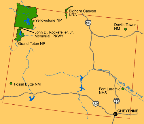
| Description | Map of Wyoming (USA), showing NPS sites of National Parks and National Landmarks: Yellowstone National Park , Grand Teton National Park , Devils Tower , etc. |
| Date | 26 April 2008 (uploaded) |
| Source |
From US Government website of U.S. National Park Service : |
| Author | Wikid77 (for upload) |

|
This
map
image could be re-created
using
vector graphics
as an
SVG
file
. This has several advantages; see
Commons:Media for cleanup
for more information. If an SVG form of this image is available, please upload it and afterwards replace this template with
{{

vector version available

|

new image name

}}
.
It is recommended to name the SVG file “Map Wyoming NPS sites USA.svg”—then the template Vector version available (or Vva ) does not need the new image name parameter. |
Licensing
|
|
This image or media file contains material based on a work of a National Park Service employee, created as part of that person's official duties. As a work of the U.S. federal government , such work is in the public domain in the United States. See the NPS website and NPS copyright policy for more information. |
|