Map_of_Asia.svg

Size of this PNG preview of this SVG file:
733 × 600 pixels
.
Other resolutions:
293 × 240 pixels
|
587 × 480 pixels
|
939 × 768 pixels
|
1,252 × 1,024 pixels
|
2,503 × 2,048 pixels
|
2,738 × 2,240 pixels
.
Summary
| Description |
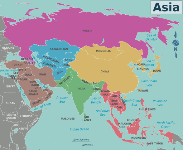
Map of Asia for use on Wikivoyage . Multilingual: in separate layers data for language codes: en, eo, fr, id, nl. Legend:
|
| Date | 5 May 2007 (original upload date) |
| Source | Own work based on the blank world map |
| Author | Cacahuate , adapted by Peter Fitzgerald , Globe-trotter , Joelf , Texugo , Piet-c and Bennylin . |
| Other versions |
PNG files: |
| Other information |
|
.png)
.png)
.png)
.png)
.png)
.png)
.png)
.png)
.png)
.png)
.png)
.png)
.png)
.png)
.png)
Licensing
This file is licensed under the
Creative Commons
Attribution-Share Alike
4.0 International
,
3.0 Unported
,
2.5 Generic
,
2.0 Generic
and
1.0 Generic
license.
-
You are free:
- to share – to copy, distribute and transmit the work
- to remix – to adapt the work
-
Under the following conditions:
- attribution – You must give appropriate credit, provide a link to the license, and indicate if changes were made. You may do so in any reasonable manner, but not in any way that suggests the licensor endorses you or your use.
- share alike – If you remix, transform, or build upon the material, you must distribute your contributions under the same or compatible license as the original.
Original upload log
|
|
This file was imported from Wikivoyage WTS. |
The original description page was
here
. All following user names refer to wts.wikivoyage-old.
- 2008-01-26 05:57 (WT-shared) Cacahuate [ dead link ] 744×1052 (407397 bytes) {{Imagecredit|credit=[[:en:User:Cacahuate|Cacahuate]]|captureDate=|location=Asia|source=Created by user|caption=Map of Asia|description=A ma (Import from wikitravel.org/shared)
- 2008-09-04 03:23 (WT-shared) Cacahuate [ dead link ] 744×1052 (2472637 bytes) new base map with better lines, fix colors, fonts, etc (Import from wikitravel.org/shared)
- 2010-03-21 17:42 (WT-shared) Peterfitzgerald archive copy at the Wayback Machine 744×1052 (2460391 bytes) add a few more country labels (Import from wikitravel.org/shared)
- 2010-12-05 06:43 (WT-shared) Joelf [ dead link ] 2738×2240 (2259001 bytes) +fr (Import from wikitravel.org/shared)
- 2011-09-07 01:37 (WT-shared) Peterfitzgerald archive copy at the Wayback Machine 2738×2240 (2005259 bytes) split Sudan/S Sudan & remove all the unnecessary, unused layers (Import from wikitravel.org/shared)
- 2011-12-28 09:17 (WT-shared) Globe-trotter [ dead link ] 2738×2240 (2148340 bytes) Added Dutch language, added Turkey to Asia (Import from wikitravel.org/shared)
- 2012-09-13 11:42 ImportBot [ dead link ] 2738×2240 (2113570 bytes) rm WT-logo
[[
 |pulgar|continentes]]