Map_of_population_of_Cantabria_2005.png

Size of this preview:
800 × 566 pixels
.
Other resolutions:
320 × 226 pixels
|
640 × 453 pixels
|
936 × 662 pixels
.
Summary
| Description |
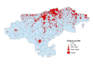
Español:
Mapa de habitantes por núcleos de población en Cantabria. Año 2005
English:
Map of habitants by villages in Cantabria. Year 2005
|
| Date | |
| Source | self-made from data of the National Statistics Institute |
| Author | Tony Rotondas |

|
File:Map of population of Cantabria 2005.svg
is a vector version of this file. It should be used in place of this PNG file when not inferior.
File:Map of population of Cantabria 2005.png →
File:Map of population of Cantabria 2005.svg
For more information, see
Help:SVG
.
|

|
Licensing
I, the copyright holder of this work, hereby publish it under the following licenses:

|
Permission is granted to copy, distribute and/or modify this document under the terms of the GNU Free Documentation License , Version 1.2 or any later version published by the Free Software Foundation ; with no Invariant Sections, no Front-Cover Texts, and no Back-Cover Texts. A copy of the license is included in the section entitled GNU Free Documentation License . |
This file is licensed under the
Creative Commons
Attribution 3.0 Unported
license.
-
You are free:
- to share – to copy, distribute and transmit the work
- to remix – to adapt the work
-
Under the following conditions:
- attribution – You must give appropriate credit, provide a link to the license, and indicate if changes were made. You may do so in any reasonable manner, but not in any way that suggests the licensor endorses you or your use.
You may select the license of your choice.